Snow this weekend for Calgary
AFTERNOON UPDATE: Welp, here we go... getting ourselves toward ten or even 15 centimetres of snow is now a distinct possibility by Sunday as we ride these waves rolling free of the foothills. The majority of models show that east Calgary and west Calgary will be quite different, as snowfall totals go. There's a very good chance we wake up to a fresh coat of the white stuff on the ground tomorrow.
MORNING EDITION: Now that we’re less than 24 hours out, the forecast models – for the most part – are starting to reach a consensus. The answer is two to five centimetres. The timeline has moved up for the Calgary region, with snow beginning to fall late this evening – with a slight shot at flakes near the dinner-hour.
It then extends out to Sunday, with a moderate chance for flurries dying off near noon.
Saturday's snow will have a heavier impact in the foothills; snowfall warnings are in place in a band through Okotoks, K-Country and Canmore, and Crowsnest Pass/Pincher Creek, where 10 to 20 centimetres is more likely.
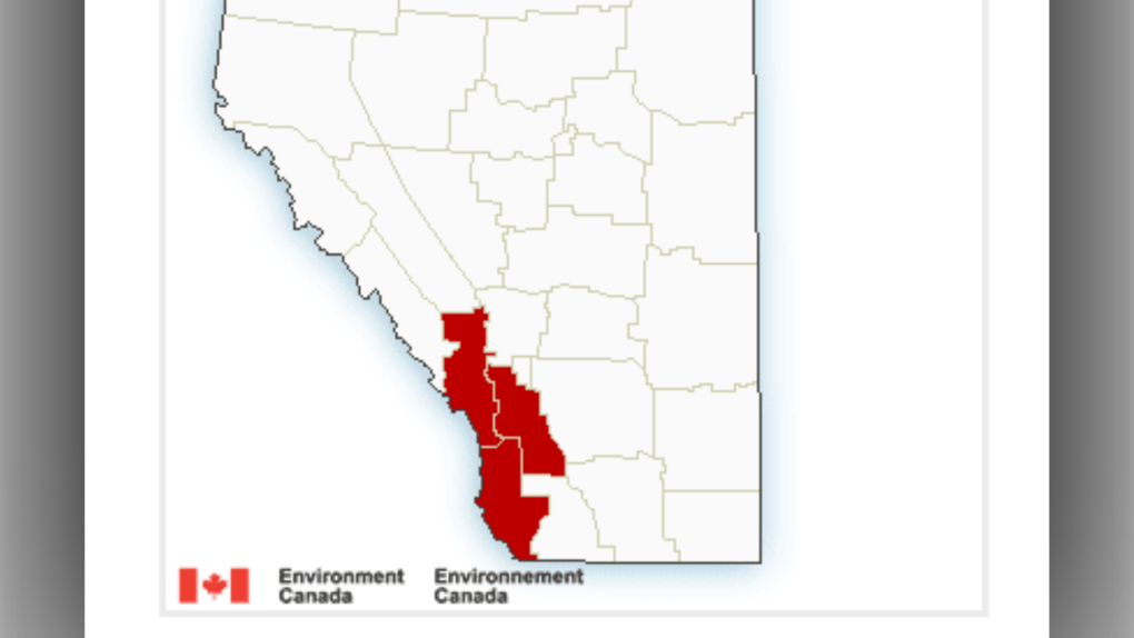 Snowfall warnings in Alberta as of Oct. 21
There remains a chance that Calgary sees up to 10 centimetres, but we're more than likely clinging to the periphery of the event; still, a commute Saturday afternoon from the east to the west end of Calgary could show stark contrasts in snow development.
A final major footnote for this snowfall; the temperature trend through Friday's low out to Sunday's high is in a range that produces watery snow; heavy, fat flakes are in order, and with them, we should expect a fair portion to melt as soon as they hit the ground.
Getting to 8 C today is certainly not spectacular compared to the rest of the month, but that’s still plenty warm enough to add a decent thermal layer to the road that inhibits snow growth (to a marginal degree).
Beyond, next week starts with a slight pop-up in temperatures… but don't hold your breath for those temps in the 20s.
YOUR FIVE-DAY CALGARY FORECAST:
Friday
- Evening: mostly cloudy, overnight showers becoming snow showers, low 0 C
Saturday
- Snow showers
- Daytime high: 3 C
- Evening: chance of mixed precipitation, low -1 C
Sunday
- Morning flurry risk, mainly cloudy
- Daytime high: 4 C
- Evening: some cloud, low -5 C
Monday
- Mainly sunny
- Daytime high: 9 C
- Evening: some cloud, low 1 C
Tuesday
- Partly cloudy
- Daytime high: 7 C
- Evening: some cloud, low -3 C
Ron in Woodbine has a preeetty nice view he wanted to share!
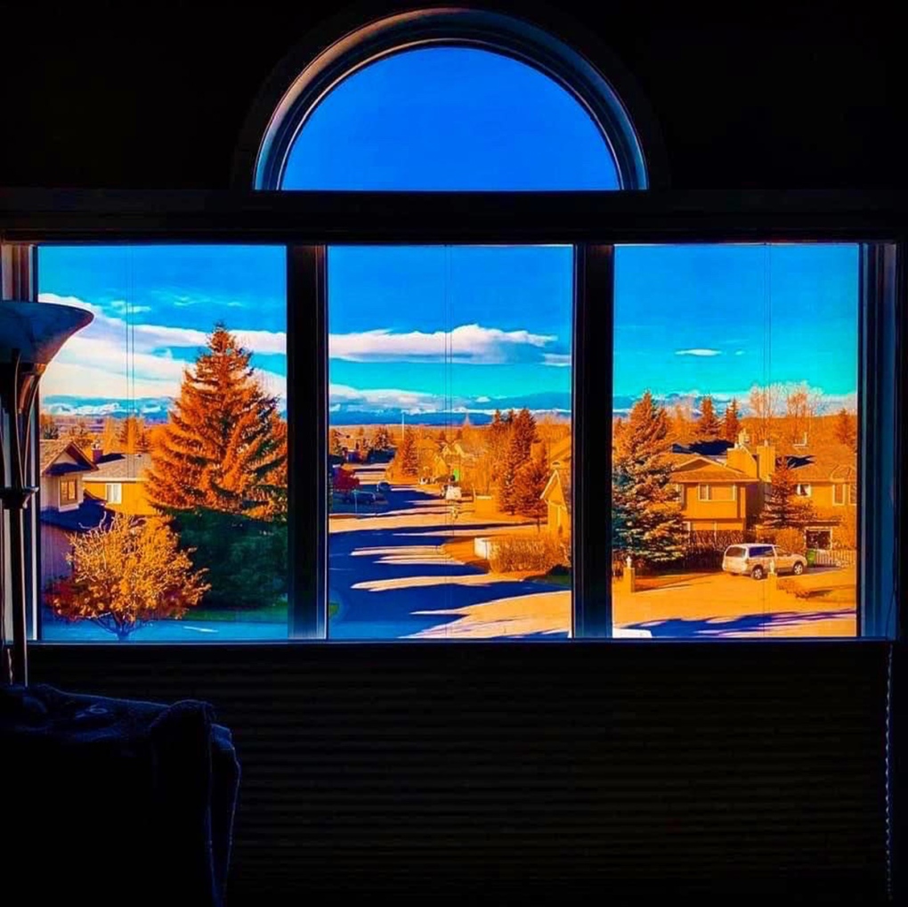 Fall colours in Woodbine photo courtesy viewer Ron.
Submit your weather photos here to see them featured in our article, and perhaps even as the pic of the day during our News at Six. You can also share to my Facebook page, on Twitter, or to our Instagram at @CTVCalgaryWeather.


CTVNews.ca Top Stories

Tensions flare between Poilievre and Singh in the House after NDP says it will back Trudeau Liberals
Conservative Leader Pierre Poilievre and NDP Leader Jagmeet Singh got into a heated exchange in the House of Commons on Thursday, just minutes after Singh announced his party would not be supporting the Conservatives' first non-confidence motion against Prime Minister Justin Trudeau's government.
'It's disgusting': Quebec minister reacts after body of boy, 14, found near Hells Angels hideout
The province's public security minister said he was "shocked" Thursday amid reports that a body believed to be that of a 14-year-old boy was found this week near a Hells Angels hideout near Quebec City.
Missing six-year-old boy disappeared after school breakfast program: Manitoba RCMP
Shamattawa RCMP are searching for a missing six-year-old boy who hasn’t been seen since Wednesday morning.
Woman dead, toddler uninjured following B.C. police shooting, watchdog says
B.C.'s police watchdog is investigating the death of a woman who was shot by the RCMP after allegedly barricading herself in a room with a toddler early Thursday morning.
PM Trudeau names Anita Anand transport minister after Pablo Rodriguez quits cabinet
Prime Minister Justin Trudeau tapped Treasury Board President Anita Anand to take on additional duties as Canada's minister of transport on Thursday.
Canadian women among those who allege Harrods boss sexually abused them
CTV News has learned there are multiple Canadian women alleging they were victims of sexual abuse at the hands of the late Harrods boss Mohamed Al Fayed.
The Royal Canadian Mounted Police has lost 205 firearms since 2020, including machine-guns
The Royal Canadian Mounted Police has lost 205 firearms since 2020, including more than 120 handguns and at least five fully automatic weapons like machine-guns.
Shohei Ohtani becomes the first major league player with 50 homers, 50 stolen bases in a season
Shohei Ohtani became the first major league player to hit 50 home runs and steal 50 bases in a season, with the Los Angeles Dodgers star going deep twice to reach the half-century mark and swiping two bags to get to 51 against the Miami Marlins on Thursday.
Francois Legault wants the Trudeau government to fall
Quebec Premier Francois Legault is calling on the Bloc Quebecois to topple the Trudeau government next Wednesday and trigger a federal election.
Shopping Trends
The Shopping Trends team is independent of the journalists at CTV News. We may earn a commission when you use our links to shop. Read about us.


Edmonton
-

5 bison killed in collision with trucks at Elk Island National Park
Five bison are dead at Elk Island National Park east of Edmonton following an early Thursday morning collision.
-
Man charged with sexually assaulting a teen is an Alberta sheriff
An Edmonton man who is charged with sexually assaulting a teen boy is a member of the Alberta sheriffs, CTV News Edmonton has confirmed.
-
Alberta mayor apologizes for comments about killing feral cats
The mayor of Fort Saskatchewan apologized on Thursday for comments she made earlier this week about killing feral cats.
Lethbridge
-

Second-degree murder charge laid after woman found dead in Oyen, Alta.
A Vulcan, Alta., man has been charged with a Lethbridge woman's murder after her body was found in the Oyen area.
-
Lethbridge couple has car stolen while waiting for an appointment
A Lethbridge couple got a good reminder as to why you should keep your vehicle doors locked at all times.
-
Lethbridge police to hold low-light shooting training exercise Wednesday and Thursday evening
Lethbridge residents who live near the police range can expect to hear plenty of shots fired Wednesday and Thursday.
Vancouver
-

Woman dead, toddler uninjured following B.C. police shooting, watchdog says
B.C.'s police watchdog is investigating the death of a woman who was shot by the RCMP after allegedly barricading herself in a room with a toddler early Thursday morning.
-
Woman nearly shut out of mother's will sues brother in B.C. Supreme Court – and wins
Since she was a young girl growing up in Vancouver, Ginny Lam says her mom Yat Hei Law made it very clear she favoured her son William, because he was her male heir.
-
'Namgis First Nation touts success of land-based fish farming
The 'Namgis First Nation says a fish farm it owns near Port McNeill shows the potential of land-based aquaculture in B.C.
Vancouver Island
-

'Seems very political': Greater Victoria teachers surprised by ministerial order on student safety
In a rare move, the Greater Victoria School District Board of Education has been slapped with a ministerial order from the province requiring it to update a student safety plan – drawing concern around political posturing leading up to an election.
-
UBCM calls for province to pay for free transit for teenagers
The Union of B.C. Municipalities is asking the provincial government to make transit free for teenagers.
-
B.C. senior recalls becoming trailblazing car designer
To appreciate why Mimi Vandermolen is so pleased to notice one particular vehicle she’s walking past, you need to know that seeing this many cars in one place would have been unimaginable when she was growing-up in the post-war Netherlands.
Saskatoon
-

Sask. mother says gym teacher at private Christian school hit her 7-year-old in the head with a relay baton
A gym teacher at a private Christian school in Saskatoon has been charged. Terra MacEwan, 44, is charged with assault with a weapon. A Saskatoon mother who spoke with CTV News says her autistic son was MacEwan's victim.
-
In letters to slain girlfriend's family, Thomas Hamp said he thinks weed caused his psychotic break
Thomas Hamp says he believed secret police were out to kidnap, torture, and kill him when he fatally stabbed his girlfriend Emily Sanche in February of 2022.
-
AI photo of purple apples growing in Sask. sparks attention, experts debunk image
A social media post of purple apples “growing” in Saskatchewan has sparked a lot of attention. However, garden experts say there's no such thing.
Regina
-

AI photo of purple apples growing in Sask. sparks attention, experts debunk image
A social media post of purple apples “growing” in Saskatchewan has sparked a lot of attention. However, garden experts say there's no such thing.
-
Sask. court orders trial in fraud case after $100K in stolen cash was traded for bitcoin
A case involving stolen funds from a Saskatchewan business being used to purchase cryptocurrency will be heading back to the courts, thanks to a new decision by Saskatchewan's Court of Appeal.
-
Tornado confirmed near Langbank, Sask.: ECCC
Environment and Climate Change Canada (ECCC) has confirmed a tornado touched down Wednesday evening near Langbank, Sask.
Toronto
-

Police search for one of suspected shooters in fatal North York double shooting
Toronto police are asking for the public's help in identifying one of the suspected shooters in Tuesday's fatal double shooting in North York.
-
Pedestrian rushed to hospital after being struck by vehicle in North York
A pedestrian has been seriously injured after being struck by a vehicle in North York.
-
Uniformed officers returning to schools in York Region, but only for safety presentations, say officials
Students across York Region will once again see uniformed officers at school, however police and board officials say they will only be stopping by for the occasional safety presentation.
Montreal
-

Francois Legault wants the Trudeau government to fall
Quebec Premier Francois Legault is calling on the Bloc Quebecois to topple the Trudeau government next Wednesday and trigger a federal election.
-
Graphic video of drive-by shooting shown at Montreal murder trial
A harrowing video has been presented to a jury at the trial of three men facing first-degree murder charges.
-
'It's disgusting': Quebec minister reacts after body of boy, 14, found near Hells Angels hideout
The province's public security minister said he was "shocked" Thursday amid reports that a body believed to be that of a 14-year-old boy was found this week near a Hells Angels hideout near Quebec City.
Atlantic
-

New Brunswick Premier Blaine Higgs officially calls provincial election
New Brunswick Premier Blaine Higgs has called for a provincial election. Voters will go to the polls on Oct. 21, as prescribed by the province's fixed-date election law.
-
Bear removed from Dartmouth Commons, area open to public again
Police are asking people to avoid the Dartmouth Commons area in Dartmouth, N.S., as they assist with a wildlife call for a bear.
-
N.S. RCMP charge 83-year-old man with sexual interference
An 83-year-old man is facing sexual interference charges following a Nova Scotia RCMP investigation.
Winnipeg
-

'I'm devastated': Manitobans cleaning up after surge of rain floods communities
Manitobans are continuing to mop up after a deluge of rain hit southern Manitoba earlier in the week.
-
Missing six-year-old boy disappeared after school breakfast program: Manitoba RCMP
Shamattawa RCMP are searching for a missing six-year-old boy who hasn’t been seen since Wednesday morning.
-
'They're dying up north': Possible parvovirus outbreak in Manitoba.
A Winnipeg pet rescue is putting out a warning to dog owners across the city about a possible parvovirus in the province.
Ottawa
-

Man dies in hospital after shooting in Heron Gate area
Police say a man who was taken to hospital in critical condition after being shot Thursday night has died.
-
Voters in Bay of Quinte elect Ontario PC candidate Tyler Allsop as new MPP
A byelection was called for the Bay of Quinte riding less than a week after Progressive Conservative MPP Todd Smith, Ontario's education minister at the time, resigned his seat in August.
-
Customers left in the dark as Upper Room Furniture files for bankruptcy
Customers are in the dark about the sudden closure of the Upper Room Furniture stores. The company has filed papers under the Bankruptcy and Insolvency Act. It’s not known whether orders placed and paid for will be honoured.
Northern Ontario
-

Heroic dog saved his northern Ont. owner who had a massive heart attack
They say a dog is a man’s best friend. In the case of Darren Cropper, from Bonfield, Ont., his three-year-old Siberian husky and golden retriever mix named Bear literally saved his life.
-
Northeastern Ontario under a high forest fire rating
As northern Ontario gets ready to welcome autumn this weekend, it’s still feeling a lot like summer as provincial forest fire crews continue to battle blazes.
-
Driver hauling 36,000 kg of ammonia arrested for impaired driving near Timmins, Ont.
James Bay Ontario Provincial Police have charged four commercial vehicle drivers with impaired, including one who was hauling 36,000 kilograms of ammonia hydrate.
Barrie
-

Two Barrie men charged in connection with double homicide at Keswick park
Two men from Barrie have been charged after a deadly shooting at a park in Keswick on Wednesday.
-
Brides and vendors claim they were ripped off by Barrie photographer
A growing group of brides and wedding photographers from across the province say they have been taken for tens of thousands of dollars by a Barrie, Ont. wedding photographer.
-
Driver charged after child is struck in Owen Sound intersection
A 32-year-old man is facing charges after police say his vehicle struck a child in an Owen Sound intersection.
Kitchener
-

Ayr couple out almost $23K after closure of Kitchener pool store
Amber and Adam Brueckner have a pool-shaped hole in their backyard – and their wallets.
-
Missing family last seen in a rideshare vehicle in Kitchener, Ont.
New details have been shared about a missing family that was last seen on Sept. 1 in Kitchener, Ont.
-
Police seek to identify 'suspicious' person
Police are trying to identify a man who approached a woman and child in Wellesley.
London
-

'If it was your backyard, would you put up with it?'; Woodstock homeowner frustrated by encampment next door
A Woodstock homeowner says she’s at her wit’s end over a homeless encampment situated alongside her backyard. She’s calling on the city to do more to help those living rough, so she can live in peace.
-
Heavy police presence in downtown London as result of weapons investigation
Police were focusing their attention on the northeast corner of Richmond and Horton, with members of the emergency response unit taking up positions at the scene.
-
Striking Western worker hit by driver: CUPE
A union representative says someone driving a pick-up truck with heavily tinted windows rammed a member on Western Road, near Elborn College.
Windsor
-
Windsor police seize $56,000 in drugs, arrest made
The Windsor Police Service (WPS) has seized over $56,000 in drugs and have arrested one suspect.
-
Global procurement solution company launches Canadian operations in Windsor-Essex
SERVEONE Canada, a global procurement solution company, has begun Canadian operations in Tecumseh.
-
St. Clair College sees increase in domestic, decrease in international students
Enrolment may be down at St. Clair College, but President Mike Silvaggi isn’t bothered.


