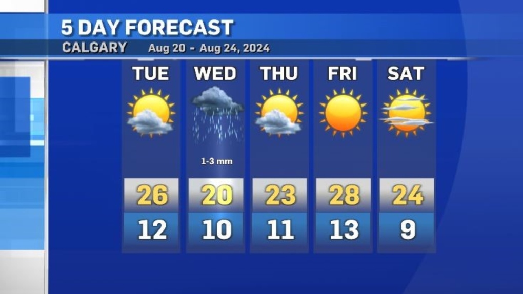
Warm and windy Tuesday in Calgary ahead of a cool and wet Wednesday
Most of southern Alberta had a mild start on Tuesday with a break from wildfire smoke and warmer temperatures.
A southwest-to-northeast weather pattern offered unlimited visibility in Calgary, Lethbridge and Medicine Hat, compared to higher levels of particulate in northern Alberta.
Winds are expected to increase throughout the day, peaking around 20 to 40 km/h out of the southwest in Calgary, as the ridge of high pressure sitting along the southern border of Alberta, Saskatchewan and Manitoba starts to track east.
A low-pressure system will slide south along the Pacific coastline, introducing instability and bringing some precipitation to southern B.C. and central and southern Alberta on Wednesday.
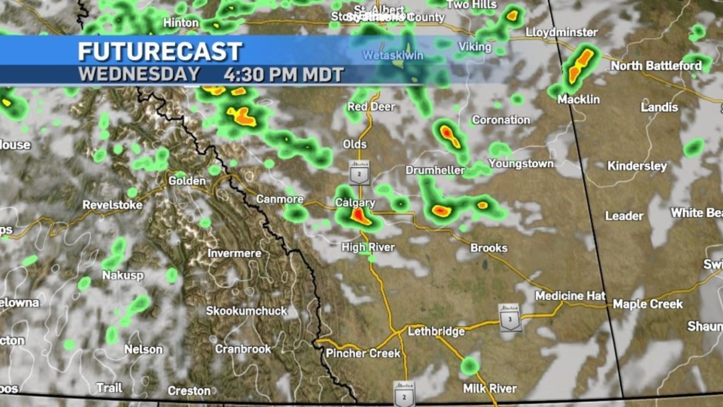 Calgary is likely to receive some rain, but accumulations will be minimal.
The rotation within this frontal system could bring smoke back in to southern Alberta for the weekend.
Daytime highs will return to above seasonal values after Wednesday, with overnight lows slightly warmer than the average of 9 C.


CTVNews.ca Top Stories

'Buy nothing': PSAC wants federal workers to boycott downtown Ottawa businesses
A union representing federal employees is asking its members to bring their own lunch to work, in an apparent retaliation against downtown Ottawa businesses as new return-to-office protocols begin.
Actions speak louder: What experts are saying about the body language in the U.S. presidential debate
The highly anticipated debate between Kamala Harris and Donald Trump was a heated matchup. Here's what experts who analyzed the exchange had to say.
Jon Bon Jovi helps talk woman down from ledge on Nashville bridge
Rock and Roll Hall of Famer Jon Bon Jovi and a video production assistant persuaded a woman standing on the ledge of a pedestrian bridge in Nashville to come back over the railing to safety.
Inside a Manitoba ghost town, a group of ladies works to keep it alive
Abandoned homes line the streets of Lauder, a town that's now a ghost of what it once was. Yet inside, a small community is thriving.
B.C. family says razor blades found in bag of frozen blueberries
The B.C. parents of an 11-year-old girl said their daughter recently found a package containing razor blades in a bag of Kirkland-brand frozen blueberries.
Langenburg UFO sighting commemorated with silver coin
Perhaps Saskatchewan's most famous encounter with Unidentified Aerial Phenomenon (UAP/UFO) – "The Langenburg Event" is now being immortalized in the form of a collective coin.
Taylor Swift wins at MTV Video Music Awards and Chappell Roan gets medieval
Taylor Swift and Post Malone took home the first award at the 2024 MTV Video Music Awards, for best collaboration, handed to them by Flavor Flav and Olympian Jordan Chiles.
Man, 70, and woman, 71, found shot dead in Montreal apartment, police
Montreal police (SPVM) are investigating after a man, 70, and woman, 71, were killed by gunshot wounds in an apartment.
Tens of thousands in the dark after Hurricane Francine strikes Louisiana with 100 m.p.h. winds
Hurricane Francine struck Louisiana on Wednesday evening as a Category 2 storm that forecasters warned could bring deadly storm surge, widespread flooding and destructive winds on the northern U.S. Gulf Coast.
Shopping Trends
The Shopping Trends team is independent of the journalists at CTV News. We may earn a commission when you use our links to shop. Read about us.


Edmonton
-

Father who killed his 17-day-old son sentenced to 6 years in prison
A man who killed his infant son two years ago has been sentenced to six years in prison.
-
3 Edmonton restaurants ranked among best new dining spots in country
Edmonton's Bar Henry. Bernadette's and Little Wolf are up for consideration for the title of Canada's best new restaurant.
-
St. Albert product 'excited' about free-agent invitation to Edmonton Oilers rookie camp
Marc Lajoie received a text from his agent two weeks ago with an offer to attend Edmonton Oilers training camp.
Lethbridge
-

Interfaith Food Bank puts out call for fresh vegetables, fruit and dairy as harvest season continues
As harvest season continues in southern Alberta, the Interfaith Food Bank in Lethbridge is putting out an urgent call for fresh food and produce.
-
Milk River Emergency Department temporarily closed Thursday
Milk River Emergency Department will be temporarily closed Thursday – but this time it’s not because of a doctor shortage.
-
Lethbridge students struggling to find jobs through the school year
Thousands of students at the University of Lethbridge and Lethbridge Polytechnic are back in Lethbridge for the school year.
Vancouver
-

Family of teen who died in B.C. homeless camp pushes for involuntary treatment for children with addictions
In February, when Brianna MacDonald was rushed to hospital because of a suspected overdose, her parents said they begged Surrey Memorial to keep her in the youth psychiatric ward because of her mental health and addiction issues.
-
Terry Fox's hometown wants public's help with new interactive exhibit
As thousands prepare to take part in Terry Fox Runs this weekend to raise money in the fight against cancer, his hometown has a new legacy project in the works.
-
More people turning to non-profit grocery store as food costs surge
More customers have been shopping the shelves of Vancouver's Quest grocery store.
Vancouver Island
-

B.C. family doctors press parties for plans to address crisis ahead of election
More than 700,000 British Columbians don't have a family doctor and two physicians’ groups want to know how the province’s political parties plan to address the crisis.
-
Family of teen who died in B.C. homeless camp pushes for involuntary treatment for children with addictions
In February, when Brianna MacDonald was rushed to hospital because of a suspected overdose, her parents said they begged Surrey Memorial to keep her in the youth psychiatric ward because of her mental health and addiction issues.
-
RCMP enforcement at B.C. logging protests 'unreasonable,' federal police watchdog says
A federal police oversight agency has found the RCMP's enforcement of a civil injunction against old-growth logging protesters on Vancouver Island was unreasonable and violated the rights of activists.
Saskatoon
-

Saskatoon Tribal Council shelter will face cuts after new proposed shelter opens: province
The proposed downtown location for the city’s newest homeless shelter is drawing criticism from the chief of the Saskatoon Tribal Council (STC), which runs the city’s largest emergency shelter.
-
Councillors endorse Saskatoon downtown planning roadmap
Saskatoon city councillors put their support behind a planning document that is expected to guide the next decade of development for the downtown core at its governance and priorities committee Wednesday.
-
'We do it well': How Elections Saskatchewan preps for voting
Saskatchewan is entering election season, with voters soon heading to the polls to determine the province’s future.
Regina
-

Langenburg UFO sighting commemorated with silver coin
Perhaps Saskatchewan's most famous encounter with Unidentified Aerial Phenomenon (UAP/UFO) – "The Langenburg Event" is now being immortalized in the form of a collective coin.
-
Town of Gravelbourg says goodbye to water tower
For as long as she can remember, 98-year-old Minnie Nugent has enjoyed the view of a water tower in the skyline, welcoming her home to Gravelbourg.
-
'Another option': Sask. widening scope of practice for pharmacists
The provincial government is widening the scope of practice for Saskatchewan pharmacists with the launch of a new pilot project.
Toronto
-

Judges quash OPP’s decision that officer misconduct in fatal crash was 'not serious'
A panel of Ontario judges has thrown out a decision by the Ontario Provincial Police that an officer’s misconduct behind the wheel that killed a pedestrian in 2020 was not serious, saying the force must reconsider, and at least explain its decision to his grieving widow.
-
Police documents detail allegations against Toronto detective accused of sexually assaulting subordinates
A Toronto police detective facing sexual assault charges is alleged to have touched subordinates inappropriately on several occasions and, in some instances, taken pictures of them while on the toilet.
-
Suspects in GTA auto theft ring came to Ontario ‘for sole purpose’ of stealing cars: Halton police
Halton Regional Police say they have disrupted a group believed to be responsible for the theft of at least 40 vehicles in Halton Region and the Greater Toronto Area worth over $3 million.
Montreal
-

74 year-old man dies after collision with vehicle in Ville-Marie
A 74-year-old man was killed after being struck by a vehicle in the Ville-Marie borough, according to Montreal police (SPVM).
-
Man, 70, and woman, 71, found shot dead in Montreal apartment, police
Montreal police (SPVM) are investigating after a man, 70, and woman, 71, were killed by gunshot wounds in an apartment.
-
Atlantic
-

'Don’t get sick on a Friday,' Bedford, N.S., MLA tells health committee
Despite data and testimony from health officials reporting progress on emergency health-care access, a Nova Scotia Liberal MLA says the system is still not up to standard.
-
'Bit of a mess': The challenges of getting around Halifax
Ongoing construction is causing traffic woes for Halifax drivers.
-
Man charged with attempted murder after Halifax shooting
A 34-year-old man is facing an attempted murder charge after an alleged shooting in the north end of Halifax last week.
Winnipeg
-

'She was very honourable': Cathy Merrick lies in state at Manitoba legislature
The sound of sombre song serenaded the halls of the Manitoba legislature Wednesday as Cathy Merrick's casket was brought in for a closed-door ceremony. Merrick died last Friday and was to lie in state Wednesday afternoon to allow the public to pay their respects.
-
Inside a Manitoba ghost town, a group of ladies works to keep it alive
Abandoned homes line the streets of Lauder, a town that's now a ghost of what it once was. Yet inside, a small community is thriving.
-
Police searching for missing 22-year-old man
Winnipeg police are asking for the public's help locating a man last seen in the Bridgwater neighbourhood.
Ottawa
-
 NEW THIS MORNING
NEW THIS MORNING Audit finds issues with apprenticeship program, outsourcing of work in OC Transpo garages
The City of Ottawa's auditor general has found issues within OC Transpo's maintenance facilities surrounding supervision and certification of apprentices and around the outsourcing of some work to other garages.
-
'Buy nothing': PSAC wants federal workers to boycott downtown Ottawa businesses
A union representing federal employees is asking its members to bring their own lunch to work, in an apparent retaliation against downtown Ottawa businesses as new return-to-office protocols begin.
-
Ottawa's mayor warns transit fare hikes, transit levy increases to address transit shortfall in 2025
Ottawa's mayor is warning of fare increases of 2.5 per cent to 75 per cent, service cuts, tax hikes, the elimination of free fares or a combination of levers to help offset a $120 million funding shortfall in the OC Transpo budget next year.
Northern Ontario
-

Public defecation leads to threats charge at northern Ont. campground
An incident involving siblings last weekend in Thessalon, Ont., ended with threats against campground staff and charges for one of the family members.
-
U.S. presidential historian predicts results of November elections. Here's who he says will win
An American presidential historian is predicting a Kamala Harris presidency as the outcome of the upcoming U.S. elections in November.
-
Lotto Max jackpot hits record $75 million, could rise to $80M
Starting Friday, Lotto Max draw participants can play for prize of $75 million for the first time ever in Canada.
Barrie
-

Police investigate fatal hit-and-run on Highway 26 involving transport truck
Police are investigating an alleged hit-and-run after an individual was found dead at the side of the road in Springwater Township early Wednesday morning.
-
Highway 12 multi-vehicle crash sends 1 person to hospital
Traffic along Highway 12 was impacted by a multi-vehicle crash.
-
OPP constable charged after alleged assault at Santa's Village
A woman has been charged with assault following an incident at an amusement park in Bracebridge.
Kitchener
-

Residents stepping up home security in Waterloo Region
In a push to make their homes more secure, a local home surveillance company says more residents are installing security cameras on their properties.
-
Civil lawsuit alleging 'brutal' sexual assault launched against accused in Ont.'s 'Woodland rapist' case
An alleged child predator who was arrested and charged earlier this year is now facing a civil lawsuit in connection with a "brutal" sexual assault in a Toronto area park reported nearly 30 years ago.
-
Police search for suspects after dog stolen in Kitchener, Ont.
A Kitchener, Ont. woman is pleading for the return of her puppy, an eight-month-old French Bulldog named Sanchi.
London
-

Victim taken to hospital with serious injuries following afternoon shooting
The London police are investigating a shooting that took place on Boullee Street in London Wednesday afternoon.
-
Sarnia police investigate collision between SUV and motorcycle
The Sarnia Police Service attended the scene of a crash in the area of Finch and Conestoga Drives Wednesday evening.
-
Traffic chaos on campus continues amid ongoing labour disruption at Western University
It’s day 13 of a strike by Western University’s facilities employees and some roads around the campus remain closed, causing delays for students and motorists.
Windsor
-

Windsor facing uphill battle to collect unpaid parking ticket revenue
The City of Windsor is struggling to collect a "significant" amount of unpaid parking ticket revenue.
-
Will a rate cut spur further building boom in Windsor? Maybe
The latest interest rate cut may not open the floodgates of construction in Windsor-Essex, according to the area’s home builders’ association.
-
Local photojournalist has retrospective of his work at museum
A local award-winning photojournalist is having a retrospective exhibit of his work in Windsor.


