Stabbing at Calgary Value Village under investigation by police
Calgary police took two people into custody on Friday after a stabbing in the community of Haysboro.
Unable to retrieve weather data
Calgary police took two people into custody on Friday after a stabbing in the community of Haysboro.

Calgary police are investigating a shooting reported in the Valleyfield industrial area on Friday.

A Calgary man has been sentenced to 30 months in prison for his role in a downtown stabbing spree last year that sent multiple people to hospital.
An investigation is underway into a Friday morning residential fire in the Calgary community of Deer Run.
Canada's largest cosplay parade is back in full force, returning to city for the 10th time on Friday.
Randall Donison says he's going to get himself a meaty reward as part of his recent lottery win.
An Alberta RCMP officer has been charged with child sexual exploitation offences.
Calgary police are asking the public for help finding a missing woman last seen in Falconridge.
It was a busy Wednesday evening for fire crews in Lethbridge County after multiple grass fires were sparked near the Kipp rail yard.

The Canadian Transportation Agency has hit a record high of more than 71,000 complaints in a backlog. The quasi-judicial regulator and tribunal tasked with settling disputes between customers and the airlines says the backlog is growing because the number of incoming complaints keeps increasing.
An orca whale calf that has been stranded in a B.C. lagoon for weeks after her pregnant mother died swam out on her own early Friday morning.
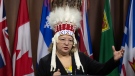
After the Assembly of First Nations' national chief complained to Air Canada about how staffers treated her and her ceremonial headdress on a flight this week, she says the airline responded by offering a 15 per cent discount on her next flight.
Sophie Gregoire Trudeau says there is 'still so much love' between her and Prime Minister Justin Trudeau, as they navigate their post-separation relationship co-parenting their three children.
The current overall public health risk posed by the H5N1 bird flu virus is low, the World Health Organization said on Friday, but urged countries to stay alert for cases of animal-to-human transmission.
Students at a Que. school are accusing their teacher of unlawfully selling their art online. Genevieve Beauchemin has the details.