With the whole province under an extreme cold warning, this is weather to take seriously
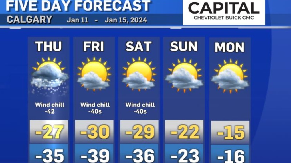
Here we go, into the most frigid three days of this cold stretch (Thursday, Friday and Saturday).
The whole province is under an extreme cold warning.
This is weather to take seriously.
Kids and pets should not be spending time outdoors.
When the wind chill is below -40, you can get frostbite in minutes.
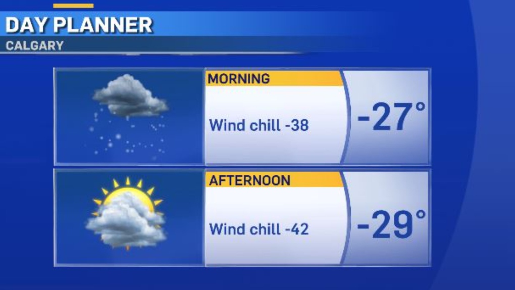
The temperatures will drop throughout the day on Thursday.
By the afternoon, wind chill values will be in the minus 40s.
Expect flurries to fully taper off Thursday afternoon.
When looking at this long-range forecast, some models are suggesting even colder temperatures than what you see here.
You can expect wind chill values to remain in the minus 40s through Saturday.
The weather pattern will start to change on Sunday with chinook winds, but with such a cold air mass in place, it will take some time for warm air to mix down to ground level and make a real difference in our temperatures at the surface.
The chinook winds should knock us into the minus single digits by Monday or Tuesday.
However, we will continue to be below normal (-3 C) for all of next week.
Stay warm everyone!
Shopping Trends
The Shopping Trends team is independent of the journalists at CTV News. We may earn a commission when you use our links to shop. Read about us.


CTVNews.ca Top Stories

Five years after toddler's brutal death, Northern Ont. family struggles to find peace, justice
A North Bay family is struggling to find peace and justice as the five-year anniversary of the brutal death of toddler Oliver McCarthy approaches.
Alberta RCMP officer charged with 2 counts of sexual assault
Const. Bridget Morla, a Leduc RCMP officer, has been charged with two counts of sexual assault in connection with an incident that happened two years ago.
Ontario dad removes hockey rink at heart of neighbour dispute
A Markham dad who drew the ire of neighbours and the city after installing a hockey rink in his backyard says the rink has now been taken down.
Kingston, Ont. doctor in 'disbelief' after being ordered to repay $600K for pandemic vaccination payments
An Ontario health tribunal has ordered a Kingston, Ont. doctor to repay over $600,000 to the Ontario government for improperly billing thousands of COVID-19 vaccinations at the height of the pandemic.
Three climbers from the U.S. and Canada are missing on New Zealand's highest peak
Three mountain climbers from the U.S. and Canada are missing after they failed to return from a planned ascent of New Zealand's highest peak, Aoraki, authorities said Tuesday.
Motivated by obsession: Canadians accused in botched California murder plot in police custody
Two Canadians are in police custody in Monterey County, California, after a triple stabbing police say was motivated by a B.C. man's obsession with a woman he played video games with online.
Trump demands immediate release of Oct. 7 hostages, says otherwise there will be 'HELL TO PAY'
President-elect Donald Trump is demanding the immediate release of the Israeli hostages still being held in Gaza, saying that if they are not freed before he is sworn into office there will be “HELL TO PAY."
Belly fat linked to signs of Alzheimer’s 20 years before symptoms begin, study says
As the size of a person’s belly grows, the memory centre of their brain shrinks and beta amyloid and tau may appear — all of this occurring as early as a person’s 40s and 50s, well before any cognitive decline is apparent, according to new research.
More RCMP and CBSA ‘human resources’ destined for border, Public Safety Minister LeBlanc says
Public Safety Minister Dominic LeBlanc says the federal government will 'absolutely' be adding more Canadian Border Services Agency (CBSA) and RCMP ‘human resources’ at the border.
Edmonton
-

Police search for man wanted in Edmonton arson, extortion cases
Edmonton police are looking for a man who they say is connected to three southside arsons this fall.
-
Alberta RCMP officer charged with 2 counts of sexual assault
Const. Bridget Morla, a Leduc RCMP officer, has been charged with two counts of sexual assault in connection with an incident that happened two years ago.
-
Hefty 2025 property tax hike looms as budget talks start
Edmonton city council discussed money in all its forms Monday at city hall – be it taxes, deficits or reserves – as it begins two weeks of budget talks.
Lethbridge
-

Hurricanes add Yager, Unger in blockbuster deal with Warriors
The Lethbridge Hurricanes received forward Brayden Yager and goalie Jackson Unger from the Moose Jaw Warriors in an 11-asset blockbuster trade on Monday.
-
Raiders hand Hurricanes sixth loss in a row, winning 3-2 in Prince Albert
The Hurricanes ended November with a loss, dropping a 3-2 decision to the Raiders Saturday night in Prince Albert.
-
University of Lethbridge launches geospatial insitute
Geomatics research is about to take a step forward at the University of Lethbridge.
Vancouver
-

'Near-zero visibility' from fog prompts weather advisory for Metro Vancouver
A fog advisory has been issued for Metro Vancouver Monday, with Environment Canada warning of the potential for "near-zero visibility."
-
North Shore Rescue reminds hikers to research trails after saving 2 unprepared tourists
Search and rescue volunteers are reminding hikers to do their research and bring the right equipment after saving two tourists who found themselves in dangerous situations on North Shore mountains.
-
Vancouver police say 'investments in public safety' are driving down crime rates
With Vancouver poised to set its 2025 budget, top police brass are touting a year-over-year decrease in crime as evidence that increased funding for the department under Mayor Ken Sim and his council is paying off.
Vancouver Island
-

Canada Post strike drying up donations for B.C. non-profit that feeds children over the weekend
For kids who rely on school meal programs for their daily nourishment, the weekend often means those children go without. Backpack Buddies helps bridge that weekend gap.
-
Driver 'doing donuts' crashes into house in Nanaimo, B.C.: RCMP
A driver who was “doing donuts” in a roundabout on a residential street in Nanaimo, B.C., lost control of his car and crashed into a home, according to police.
-
'A piece of our hearts missing:' B.C. family announces tragic end to search for missing man with dementia
A 64-year-old man who went missing from his Saanich long-term care home last month has been found deceased on the Westshore – with his wallet and Cleveland Browns trading cards, according to family.
Saskatoon
-

Over 7,000 Sask. patients have intimate medical info breached in lab hack
Over 7,000 patients in Saskatchewan had their intimate medical information breached by hackers, according to the province’s privacy watchdog.
-
Family of Sask. man who died following a violent arrest still pushing for answers
Friends and family of Boden Umpherville may be closer to finding answers on the circumstances surrounding his death.
-
Saskatchewan farmers voice concerns as U.S. tariff talks heat up
The looming threat of a 25 per cent tariff on goods imported to the U.S. is causing turmoil for Saskatchewan farmers, according to the Agricultural Producers’ Association of Saskatchewan (APAS).
Regina
-

Government of Saskatchewan introduces affordability act with personal income tax measures
The Government of Saskatchewan has introduced promised legislation to lower personal income tax in the province.
-
Manz found guilty of one charge of sexual assault, acquitted on five others after 57 hours of deliberations
After being sequestered for more than 57 hours, a 12-person jury has found Regina chiropractor Ruben Manz guilty of one count of sexual assault.
-
Blockbuster WHL trade sees Warriors move captain Brayden Yager to Hurricanes
The Western Hockey League's (WHL) Moose Jaw Warriors traded captain Brayden Yager to the Lethbridge Hurricanes Monday.
Toronto
-

Toronto library apologizes after staff at east-end branch refuse to help lost girl
The Toronto Public Library is apologizing after staff at a branch in the city’s east end refused to provide a lost child with access to a telephone.
-
Metrolinx CEO Phil Verster tenders resignation after 7 years
Metrolinx CEO Phil Verster is stepping down. Verster tendered his resignation on Monday in order to take a new position and will leave his role as CEO of the provincial transit agency as early as Dec. 16.
-
Born and bred Toronto fire: Jim Jessop named Chief after following in father's footsteps
Thirty-five years after a devastating fire roared through a Parliament Street rooming house two days before Christmas, Deputy Fire Chief Jim Jessop pulls up a grainy photo of the blaze on his phone.
Montreal
-

New poll suggests Legault even less popular than Justin Trudeau
A prominent polling analyst says Quebec's governing party would be reduced to fewer than 10 seats in the provincial legislature if an election were held today, based on current poll numbers.
-
Montreal's Metro will have extended service hours on New Year’s Eve
To help Montrealers celebrate the holidays safely, the Metro will run later than usual on New Year’s Eve.
-
Correctional officer hospitalized after being severely beaten by inmate at Quebec prison: police
A correctional officer was seriously injured after being attacked by an inmate at a prison northeast of Montreal.
Atlantic
-

Nova Scotia lawyer suspended following ugly courtroom fracas
A Nova Scotia lawyer who had to be restrained by deputy sheriffs during a court appearance earlier this year has lost his appeal of a suspension following the bizarre incident.
-
Woman dies after side-by-side crash in Belnan, N.S.
A 22-year-old woman has died following a collision between a side-by-side and a vehicle in Belnan, N.S., over the weekend.
-
Man dead, another injured after suspicious New Brunswick house fire
One man is dead and a second is badly injured after a suspicious house fire in Coal Creek, N.B.
Winnipeg
-

Investigation launched into Manitoban’s death after medical emergency at dental appointment
The Manitoba Dental Association (MDA) said it is investigating a critical incident where a young woman from the Morden-Winkler area died following a dental appointment.
-
'It's a little scary': Manitoba colleges and universities beefing up security measures
As of Monday, students and staff at Red River College are being greeted by security officers at the entrances, letting them know they will require ID as of Jan. 1.
-
Material at Manitoba landfill now being searched for remains of Indigenous women
The next stage in the search for the remains of two slain Indigenous women in a Manitoba landfill has officially begun.
Ottawa
-

Kingston, Ont. doctor in 'disbelief' after being ordered to repay $600K for pandemic vaccination payments
An Ontario health tribunal has ordered a Kingston, Ont. doctor to repay over $600,000 to the Ontario government for improperly billing thousands of COVID-19 vaccinations at the height of the pandemic.
-
City of Ottawa's auditor general finds kickback scheme involving city employee and local landlords
The City of Ottawa's auditor general has found that a city employee was engaged in a kickback scheme with a group of four local landlords, collecting thousands of dollars in payments in exchange for more favourable rental rates under specific housing benefit programs administered by the city.
-
Ottawa Police Service Board approves 2025 draft budget
Ottawa police will be asking city taxpayers for an extra $16 million next year to hire more officers and launch new programs in the nation's capital.
Northern Ontario
-
Five years after toddler's brutal death, Northern Ont. family struggles to find peace, justice
A North Bay family is struggling to find peace and justice as the five-year anniversary of the brutal death of toddler Oliver McCarthy approaches.
-
Transport trucks collide head-on near Hearst, Ont.
One transport truck driver was seriously injured Saturday when two commercial motor vehicles collided head-on on Highway 11
-
Northwestern Ontario community fined for refusing to celebrate Pride Month
An Ontario town and its mayor have been fined a total of $15,000 for refusing to celebrate Pride Month.
Barrie
-

Highway closures persist southbound from Huntsville to Orillia: OPP
Southbound lane closures remain in effect from Highway 60 in Huntsville to Highway 11 in Orillia on Monday evening.
-
New bridge over Highway 400 in Barrie opens to traffic
The Sunnidale Road bridge replacement is complete, with the road opening to traffic Monday.
-
Gravenhurst left digging out after town's most significant early snowfall ever
The Town of Gravenhurst is in recovery mode after 140 centimetres of snow fell over the weekend, marking the town’s most significant early snowfalls on record.
Kitchener
-

Criticism over OPP’s lack of communication during nine-hour closure of Hwy 401
Many people are wondering why Ontario Provincial Police failed to properly notify drivers of an investigation that shut down a stretch of Highway 401 for almost nine hours on Friday night.
-
Food Bank of Waterloo Region says demand for assistance jumped 25 per cent in 2024
A sharp and steady increase in the number of people accessing food assistance in Waterloo Region means what they receive may not be as much – or as diverse – as in the past.
-
Experts surprised by rising number of walking pneumonia cases
Experts say a rise in respiratory illness is expected as the temperature drops, but this year, they’re seeing a surprising number of walking pneumonia cases in younger people.
London
-

Tie votes could tie-up decision making by city council—unless Stevenson relents
Marathon council meetings could get even longer because a standing committee with an even number of members is raising the risk of deadlocked votes.
-
'It's painful to see that': Neighbours express concern for children impacted by Sarnia homicide investigation
Just before 5 a.m. on Sunday, police were called to a rooming house 194 Queen St. where two residents were involved in a physical fight while in the kitchen.
-
Startling admission by defence at bush bash shooting trial
As the lengthy bush bash shooting trial resumed this week, the day started with a stunning admission from defence lawyer Ricardo Golec, who represents the accused in this case, 23-year-old Carlos Guerra Guerra.
Windsor
-
-
Overnight warming centre opens early as cold weather sparks fear winter could be deadly
With winter approaching quickly, worry is settling in that the cold weather could soon turn deadly, prompting a Chatham homeless centre to extend their overnight hours early while waiting for proper approvals and financial commitments.
-
'We don’t give up on people': Windsor mobile soup kitchen moving indoors
A mobile soup kitchen in downtown Windsor is moving indoors.


