Cold replaced with snow, as new winter woes impact Alberta and B.C.
The record-breaking cold that impacted Western Canada has finally moved out of most of central and southern Alberta and British Columbia.
The temperature in Calgary on Tuesday at 7:30 a.m. was -9 C, with surrounding communities between -8 C (Strathmore), -9 C (Cochrane and Airdrie) and -12 C (Okotoks).
Warm westerly winds at the surface early in the day will hold temperatures in that range until another shift in weather patterns introduces colder air once again.
An ample supply of precipitation from the north Pacific is already translating to snowfall in northern British Columbia.
For most of Tuesday and Wednesday that snow will track from north-central B.C. toward southeastern Alberta, initially impacting areas like Jasper National Park.
The incoming northerly flow will counter that initial weather pattern that brought in warmth and push snow and colder air in toward southwestern Alberta. This potential upsloping in the foothills prompted a snowfall warning from Environment and Climate Change Canada that extends along the southern edge of the province as far east as Magrath, Claresholm and Fort Macleod and covers most of highway 2 south of Calgary.
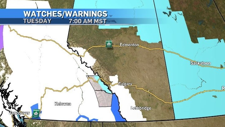 Weather warnings issued by Environment and Climate Change Canada as of 7 a.m. Tues. Jan. 16, 2023. Snowfall warnings (white), winter storm warnings (blue), special weather statements (translucent white) and extreme cold warnings (teal).
- Read more: Snowfall warning called in southern Alberta
- Get local, live and breaking news right to your email inbox. Sign up for our daily newsletter
Calgary is likely just outside of this region of highest accumulations in southwestern Alberta with five to 10 centimetres of snow forecast for the city.
As per the warning from ECCC, areas under that snowfall warning including Canmore, Kananaskis, Okotoks, High River and Crowsnest Pass could record 15 to 25 centimetres of snow with this weather event.
It is possible that areas like Waterton Lakes National Park and Pincher Creek might see totals closer to 35 centimetres.
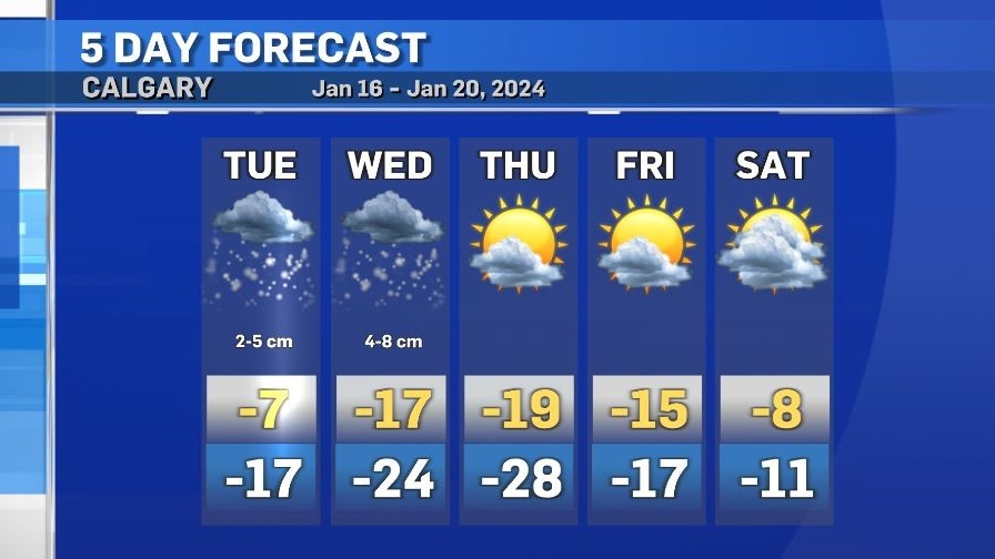
Road conditions and temperature will be quite mild early Tuesday in southern Alberta with a forecast high of -7 C for Calgary, but that warmup will be short-lived with highs on Wednesday, Thursday and Friday 12 to 16 degrees below seasonal.
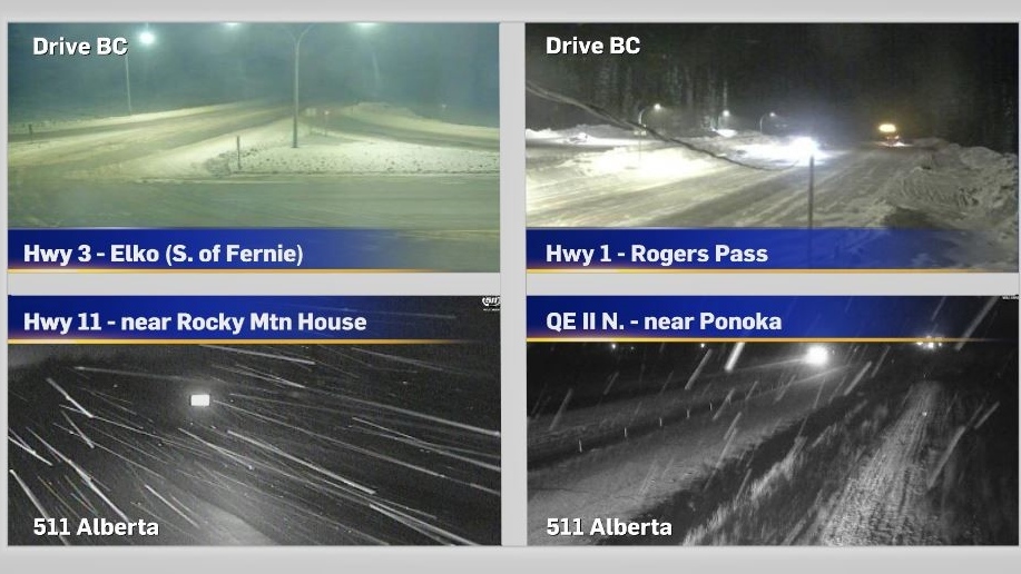
Snow was already impacting highways in central Alberta and portions of southern Alberta by 7:30 a.m. Winter-driving conditions could also be observed in southern British Columbia.
Gap winds in southwestern Alberta will translate to wind speeds of up to 80 km/h, which is below a wind warning threshold for that region, but still strong enough to impact drivers.
For the latest weather advisories from ECCC click here, click here for current highway conditions from 511 Alberta, or here for the latest from Drive BC.
Calgary is unlikely to see an average daytime high of -3 C before next week, however the temperature will warm up by the weekend.
Calgary Top Stories
-
-
-
 LIVE at 3:30
LIVE at 3:30 Alberta to announce auto insurance reforms Thursday afternoon
-
-
-
-
-


CTVNews.ca Top Stories

From essential goods to common stocking stuffers, Trudeau offering Canadians temporary tax relief
Canadians will soon receive a temporary tax break on several items, along with a one-time $250 rebate, Prime Minister Justin Trudeau announced Thursday.
'It didn't sound good': Mother shares what her sons went through with walking pneumonia
A mother shares with CTVNews.ca her family's health scare as medical experts say cases of the disease and other respiratory illnesses have surged, filling up emergency departments nationwide.
Putin says Russia attacked Ukraine with a new missile that he claims the West can't stop
Russian President Vladimir Putin announced Thursday that Moscow has tested a new intermediate-range missile in a strike on Ukraine, and he warned that it could use the weapon against countries that have allowed Kyiv to use their missiles to strike Russia.
Manitoba RCMP issue Canada-wide warrant for Ontario semi-driver charged in deadly crash
Manitoba RCMP have issued a Canada-wide arrest warrant for the semi-driver involved in a crash that killed an eight-year-old girl and her mother.
Taylor Swift's motorcade spotted along Toronto's Gardiner Expressway
Taylor Swift is officially back in Toronto for round two. The popstar princess's motorcade was seen driving along the Gardiner Expressway on Tuesday afternoon, making its way to the downtown core ahead of night four of ‘The Eras Tour’ at the Rogers Centre.
Here's a list of items that will be GST/HST-free over the holidays
Canadians won’t have to pay GST on a selection of items this holiday season, the prime minister vowed on Thursday.
Mother charged after infant dies in midtown Toronto: police
The mother of an infant who died after being found at an apartment building in midtown Toronto on Wednesday has been charged with failing to provide the necessaries of life.
Trudeau says Canada would 'abide' by ICC arrest warrant for Israel PM Netanyahu
Prime Minister Justin Trudeau said Canada will 'abide' by an International Criminal Court (ICC) arrest warrant for Israeli Prime Minister Benjamin Netanyahu.
Tired, lead-footed and distracted: Majority of Canadian drivers admit to bad habits, survey finds
Canadian drivers are regularly in a hurry to get to their destination and a majority are willing to take unnecessary risks on the road, according to the results of a new survey.
Shopping Trends
The Shopping Trends team is independent of the journalists at CTV News. We may earn a commission when you use our links to shop. Read about us.


Edmonton
-
 LIVE
LIVELIVE Edmonton police chief to step down in February
Dale McFee will retire as head of the Edmonton Police Service (EPS) on Feb. 21, the Edmonton Police Commission said in an email on Wednesday.
-
LIVE at 3:30
LIVE at 3:30 Alberta to announce auto insurance reforms Thursday afternoon
The Alberta government will announce new automobile insurance reforms Thursday afternoon.
-
Alberta forecasts $4.6B surplus in budget update, but braces for uncertainty
Alberta is forecasting a $4.6-billion surplus for this fiscal year, but Finance Minister Nate Horner says "mounting pressures" threaten to soon put the province in the red.
Lethbridge
-
Driver killed in Trans-Canada Highway crash near Salmon Arm, B.C.
B.C. RCMP say one person was killed in a head-on crash on the Trans-Canada Highway near Salmon Arm on Wednesday.
-
Giving Machine at Lethbridge's Park Place Mall sells you things that go straight to people in need
There’s a new way to give this holiday season.
-
Charges laid in September assault of 16-year-old: Lethbridge police
Lethbridge police say four teenagers have been arrested in connection with an autumn attack that saw a 16-year-old badly injured.
Vancouver
-

B.C. RCMP detachments begin rollout of body worn cameras
The B.C. RCMP has begun its rollout of police-worn cameras, and officers with the Mission detachment will be the first to use them next week.
-
B.C. man who sold Porsche to scammers shares cautionary tale
A man from B.C.’s Lower Mainland who was scammed while selling his Porsche Cayenne online is sharing his cautionary tale – while calling for increased protections from the government.
-
1 dead after Nanaimo house fire, RCMP say
One person is dead after a fire that destroyed a home in Nanaimo's south end Wednesday morning.
Vancouver Island
-

1 dead after Nanaimo house fire, RCMP say
One person is dead after a fire that destroyed a home in Nanaimo's south end Wednesday morning.
-
Another windstorm headed to B.C.’s South Coast Friday, Environment Canada says
Another fall storm is forecast to bring high winds to B.C.’s South Coast on Friday, Environment Canada says.
-
Near-record gusts knock out power to 150K Vancouver Island customers; BC Hydro brings in reinforcements from mainland
The clean up was well underway Wednesday on Vancouver Island after a night of chaos.
Saskatoon
-

Alberta non-profit Mustard Seed to run Saskatoon's Lighthouse
Alberta-based non-profit the Mustard Seed is stepping up to run Saskatoon's Lighthouse.
-
Saskatoon Friendship Centre opens emergency warming shelter
As Saskatoon recovers from Monday night’s snowstorm, community organizations are stepping up to provide shelter and support to those experiencing homelessness.
-
Saskatchewan teen still recovering in hospital after being set on fire at school
A 15-year-old girl who was set on fire at a Saskatoon high school earlier this fall is still recovering in hospital.
Regina
-

Contractor fatally injured while on the job at Regina's Evraz plant
Evraz North America says an investigation is underway after a contractor was fatally injured while on the job in Regina on Nov. 19.
-
'I'll always be a Pat': Regina Pats trade captain Tanner Howe to Calgary
The Regina Pats have announced a blockbuster trade Thursday that sees captain Tanner Howe on his way to Calgary to play for the Hitmen as the team continues rebuilding for the future.
-
Jeremy O'Day speaks on wins, losses and Riders' overall performance in 2024
The Grey Cup Champion has officially been crowned for the 2024 season and once again it did not go to the Saskatchewan Roughriders. On Thursday, General Manager, Jeremy O'Day, spoke to media to break down another year.
Toronto
-

Taylor Swift's motorcade spotted along Toronto's Gardiner Expressway
Taylor Swift is officially back in Toronto for round two. The popstar princess's motorcade was seen driving along the Gardiner Expressway on Tuesday afternoon, making its way to the downtown core ahead of night four of ‘The Eras Tour’ at the Rogers Centre.
-
Mother charged after infant dies in midtown Toronto: police
The mother of an infant who died after being found at an apartment building in midtown Toronto on Wednesday has been charged with failing to provide the necessaries of life.
-
From essential goods to common stocking stuffers, Trudeau offering Canadians temporary tax relief
Canadians will soon receive a temporary tax break on several items, along with a one-time $250 rebate, Prime Minister Justin Trudeau announced Thursday.
Montreal
-

Pro-Palestinian protest, counter-protest ongoing at Concordia University
The lobby of Concordia University’s Hall Building was flooded with pro-Palestinian protesters Thursday as others gathered and chanted outside the campus as part of Quebec-wide solidarity strikes.
-
Quebec fiscal update: $2.1B in new spending, axes tax credit for older workers
Quebec Finance Minister Eric Girard tabled an economic update on Thursday with $2.1 billion in new spending over five years amid what he described as a stronger-than-expected recovery from last year's economic slowdown.
-
Northvolt says Quebec battery plant will proceed despite bankruptcy filing
Northvolt AB has filed for bankruptcy protection in the United States, but said the move will not jeopardize the manufacturer's planned electric vehicle battery plant in Quebec — though hundreds of millions of taxpayer dollars invested in the parent company could be lost.
Atlantic
-
From essential goods to common stocking stuffers, Trudeau offering Canadians temporary tax relief
Canadians will soon receive a temporary tax break on several items, along with a one-time $250 rebate, Prime Minister Justin Trudeau announced Thursday.
-
'This is cold': P.E.I. mother upset over decision to remove late daughter's photos from school memorial wall
A high school on Prince Edward Island is removing pictures of its late students from a memorial wall – a decision that has upset one mother whose daughter attended the school.
-
Fredericton man facing several charges after five people taken hostage
A 36-year-old Fredericton man is facing several charges, including forcible confinement, after police say five people were taken hostage in the city.
Winnipeg
-

Manitoba RCMP issue Canada-wide warrant for Ontario semi-driver charged in deadly crash
Manitoba RCMP have issued a Canada-wide arrest warrant for the semi-driver involved in a crash that killed an eight-year-old girl and her mother.
-
1991-2024
1991-2024 Winnipeg Sea Bears player Chad Posthumus dies at 33
Sea Bears centre Chad Posthumus has died at age 33.
-
From essential goods to common stocking stuffers, Trudeau offering Canadians temporary tax relief
Canadians will soon receive a temporary tax break on several items, along with a one-time $250 rebate, Prime Minister Justin Trudeau announced Thursday.
Ottawa
-

uOttawa to reconsider participation in U-Pass if city increases student fares, student union says
The student union at the University of Ottawa says it will consider pulling its participation from the U-Pass, which provides discounted transit fares for students, if the city goes forward with hiking student transit fees and violating the program’s contract.
-
McDonald's Canada CEO not ruling out a return to the ByWard Market
McDonald's Canada says it has not closed the door on a return to Ottawa's downtown.
-
From essential goods to common stocking stuffers, Trudeau offering Canadians temporary tax relief
Canadians will soon receive a temporary tax break on several items, along with a one-time $250 rebate, Prime Minister Justin Trudeau announced Thursday.
Northern Ontario
-

Province pulls funding for North Bay addiction treatment centre
After years of delays, the province has pulled the plug on an addiction treatment centre in North Bay. A news release from Canadore College on Thursday confirmed the centre won’t be moving forward.
-
From essential goods to common stocking stuffers, Trudeau offering Canadians temporary tax relief
Canadians will soon receive a temporary tax break on several items, along with a one-time $250 rebate, Prime Minister Justin Trudeau announced Thursday.
-
$3M donation to help repair arena in Elliot Lake
The City of Elliot Lake said Thursday it has received a $3-million donation from Edward and Suzanne Rogers for the Centennial Arena restoration.
Barrie
-

How to avoid the number one cause of lung cancer in non-smokers, according to health experts
Radon is the number one cause of lung cancer in non-smokers in Canada, according to Grey Bruce Public Health Unit.
-
Driver witnesses two early morning collisions along one sideroad
It was a busy morning on Sideroad 5 after a driver witnessed two collisions which police say were caused by poor road conditions.
-
One person seriously injured after rollover collision in Oro-Medonte
Emergency crews had to rescue one person trapped inside a vehicle after a rollover collision in Oro-Medonte Thursday morning.
Kitchener
-

Grand River Transit LRT involved in Kitchener crash
A busy Kitchener street could be closed for several hours after a crash involving a Grand River Transit vehicle.
-
From essential goods to common stocking stuffers, Trudeau offering Canadians temporary tax relief
Canadians will soon receive a temporary tax break on several items, along with a one-time $250 rebate, Prime Minister Justin Trudeau announced Thursday.
-
Members of motorcycle gangs facing more charges following Cambridge robbery
Four members of the Hells Angels Motorcycle Club and one member of the Red Devils Motorcycle Club are facing robbery and weapons charges as part of an ongoing investigation.
London
-

'Eggs are still $6': living wage continues to climb across Ontario
It’s almost as expensive to live in Exeter as it is in downtown Toronto - that’s according to a recent report from the Ontario Living Wage Network.
-
Goderich man charged with sex crimes and luring a child: police
A 21-year-old Goderich man is facing a more than 20 criminal charges related to sex crimes, and police believe there may be more victims.
-
Minor injuries reported after two-vehicle crash
Shortly after 8 a.m. crews were called to the intersection of Oxford Street and Colborne Street where the crash left a vehicle smashed into a light standard.
Windsor
-

Woman sought following serious assault in west Windsor
Windsor police are asking for the public’s help identifying a suspect wanted in connection to an alleged serious assault that happened this past summer.
-
Illegal cannabis storefront shut down in Leamington
Essex County OPP have shut down an illegal cannabis storefront in Leamington and seized $13,500 in products.
-
Expanded primary healthcare clinic opens in Windsor
Residents living on Windsor’s west side now have expanded access to primary healthcare services.


