Warm and windy weekend with frost possible overnight in some communities
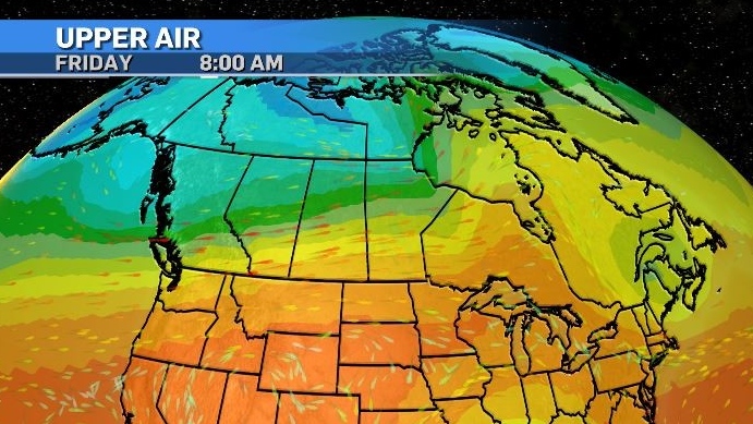
A very strong west-to-east pattern has established in the southern Prairies – from B.C. through to Manitoba.
As a result, westerly winds are expected to increase throughout the day peaking at 30 to 50 km/h for sustained winds in Calgary with gusts that are even stronger.
This synoptic setup will likely channel winds through two key corridors of the Rockies, including the southwestern corner (near Pincher Creek) and along the northern edge (near Grand Prairie).
As of 7:30 a.m., wind warnings had already been issued for portions of northern British Columbia and the Grand Prairie region on the Alberta side of the border with gusts of up to 90 km/h possible.
The wind warning threshold for southwestern Alberta is slightly higher due to more frequent stronger winds.
A wind warning can be issued for Pincher Creek, Crowsnest Pass, Lethbridge, Waterton, Cardston when sustained winds reach at least 80 km/h and/or gusts of at least 100 km/h, as opposed to 70 km/h for sustained winds and/or wind gusts of at least 90 km/h for the rest of Alberta.
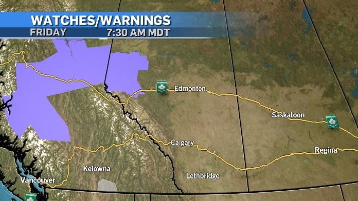 Wind warnings issued by Environment and Climate Change Canada (purple) on Friday, Sep. 27, 2024.
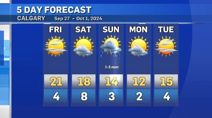
Conditions will remain mostly clear over the weekend and temperatures are expected to hover around 0 C.
For low-lying areas, or communities near water, or those outside of major centres that means frost is likely.
Within Calgary, the lows will mostly be slightly above freezing, but, again, location matters.
Daytime highs and lows will gradually decrease until Monday as a low pressure centre brings a cooler air mass from the north.
But even with that, cooldown temperatures will remain at, or above, seasonal for most of the next five days.


CTVNews.ca Top Stories

Economists say temporary tax cut, relief cheques play into rosier growth picture
The federal government's 'meaty' move to pause federal sales tax on a long list of items and send cheques to millions of Canadians this spring could factor into an improving outlook for growth in 2025, economists say.
Trump chooses Pam Bondi for attorney general pick after Gaetz withdraws
U.S. president-elect Donald Trump on Thursday named Pam Bondi, the former attorney general of Florida, to be U.S. attorney general just hours after his other choice, Matt Gaetz, withdrew his name from consideration.
Second Australian teen dies in tainted alcohol case in Laos that has killed 6 tourists
A second Australian teenager who fell critically ill after drinking tainted alcohol in Laos has died in a hospital in Bangkok, her family said Friday, bringing the death toll in the mass poisoning of foreign tourists to six.
Bears find a buffet of battlefield rations at Alaska military base
Hungry bears broke into a storage room at Joint Base Elmendorf-Richardson in this U.S. to feast on the military rations.
'Not good for the economy': MPs call on federal government to regulate resale concert tickets
Ticket fraud and sky-high prices for Taylor Swift concerts have some politicians calling for changes to the way tickets are sold in Canada.
Canada Post strike may affect delivery of kids' letters to Santa
Montreal school children spent an afternoon writing up their wish list to send to the North Pole.
A one-of-a-kind Royal Canadian Mint coin sells for more than $1.5M
A rare one-of-a-kind pure gold coin from the Royal Canadian Mint has sold for more than $1.5 million. The 99.99 per cent pure gold coin, named 'The Dance Screen (The Scream Too),' weighs a whopping 10 kilograms and surpassed the previous record for a coin offered at an auction in Canada.
South Korea says Russia supplied air defence missiles to North Korea in return for its troops
Russia has supplied air defence missile systems to North Korea in exchange for sending its troops to support Russia's war efforts against Ukraine, a top South Korean official said Friday.
From essential goods to common stocking stuffers, Trudeau offering Canadians temporary tax relief
Canadians will soon receive a temporary tax break on several items, along with a one-time $250 rebate, Prime Minister Justin Trudeau announced Thursday.
Shopping Trends
The Shopping Trends team is independent of the journalists at CTV News. We may earn a commission when you use our links to shop. Read about us.


Edmonton
-

Alberta pitches new rules for auto insurance, including rate hikes, no-fault claims
The Alberta government is making changes to auto insurance, including rate hikes and switching to a predominantly no-fault claims model.
-
Cartmell, Caterina running to be Edmonton's next mayor
Two city councillors, one sitting and one former, will be running for mayor in 2025.
-
A tax break and cut cheques: Ottawa announces relief plan for cash-strapped Canadians
It's an announcement meant to appeal to cash-strapped Canadians—a tax break impacting everything from groceries to children's clothes to diapers—and it will last for two months.
Lethbridge
-

Hurricanes kick off U.S. road trip with a loss, falling 4-0 to Silvertips
The Hurricanes launched a three-game road trip south of the border Wednesday dropping a 4-0 game to the league-best Everett Silvertips.
-
Lethbridge residents asked to show some love to downtown businesses during holidays
A new citywide campaign is hoping to encourage residents to shop, eat and explore local this holiday season.
-
Lethbridge career exploration day aims to get women more involved in agriculture
Agriculture is an industry mainly dominated by men, but around 80 middle school and high school students – all of whom are female – are hoping to change that.
Vancouver
-

Vancouver police ignore FOI requests for chief's communications
For nearly a year, the Vancouver Police Department has failed to fulfill two freedom of information requests seeking records from Chief Adam Palmer and other high-ranking officials – a situation transparency advocates call highly concerning, and potentially illegal.
-
B.C. Conservatives roll out shadow cabinet and leadership roles for all 44 caucus members
All 44 members of the B.C. Conservative caucus have been appointed to leadership positions – whether as shadow cabinet members or Opposition house leader.
-
Vancouver youth soccer coach says racism complaint went uninvestigated for a year
The coach of a soccer team in the Vancouver Youth Soccer Association claims a complaint about racism directed at 13-year-old players on his team went unaddressed for more than a year.
Vancouver Island
-

Major crime investigators reviewing death of Victoria teen, which coroner reclassified as homicide
Vancouver Island’s major crime unit is investigating the case of a Victoria teenager whose death was initially ruled an accidental overdose, but has since been reclassified by coroners as a homicide.
-
B.C. Conservatives roll out shadow cabinet and leadership roles for all 44 caucus members
All 44 members of the B.C. Conservative caucus have been appointed to leadership positions – whether as shadow cabinet members or Opposition house leader.
-
1 dead after Nanaimo house fire, RCMP say
One person is dead after a fire that destroyed a home in Nanaimo's south end Wednesday morning.
Saskatoon
-

Sask. principal has sexual assault conviction overturned in light of 'butt-grabbing game'
A Saskatchewan principal convicted to six months behind bars for sexual assault has another chance to prove he’s the victim of a middle-school prank that escalated out of control.
-
Saskatoon's first female mayor sworn in
After being sworn in Wednesday night alongside a mix of new and returning city councillors, Cynthia Block becomes the first female mayor of Saskatoon.
-
Sask. tuxedo business closes stores across the province
A Saskatchewan tuxedo business says struggles with inflation and operating costs have caused it close stores across the province.
Regina
-

Accused of sexual assault, Regina chiropractor takes the stand as first defense witness
A Regina chiropractor accused of sexually assaulting seven different women took the stand Thursday as arguments began in his defense.
-
Contractor fatally injured while on the job at Regina's Evraz plant
Evraz North America says an investigation is underway after a contractor was fatally injured while on the job in Regina on Nov. 19.
-
'I'll always be a Pat': Regina Pats trade captain Tanner Howe to Calgary
The Regina Pats have announced a blockbuster trade Thursday that sees captain Tanner Howe on his way to Calgary to play for the Hitmen as the team continues rebuilding for the future.
Toronto
-

'Not good for the economy': MPs call on federal government to regulate resale concert tickets
Ticket fraud and sky-high prices for Taylor Swift concerts have some politicians calling for changes to the way tickets are sold in Canada.
-
Toronto Santa Claus Parade organizers 'optimistic' after funding comes in for 2025 event
The organizers of Toronto’s Original Santa Claus Parade are hopeful that the Jolly Old Elf will be coming to town for years to come.
-
Economists say temporary tax cut, relief cheques play into rosier growth picture
The federal government's 'meaty' move to pause federal sales tax on a long list of items and send cheques to millions of Canadians this spring could factor into an improving outlook for growth in 2025, economists say.
Montreal
-

Montreal says no to water fluoridation
Lachine Mayor and member of Projet Montreal Maja Vodanovic said the city will not reopen the debate on water fluoridation.
-
2 men arrested after man stabbed in Milton Park
A 46-year-old man is recovering in the hospital after he was stabbed in the Milton Park neighbourhood of Montreal on Thursday night.
-
Montreal North borough computer system hacked, police investigating
The Montreal North borough said on Thursday that 'an intrusion into its computer system' has meant that the borough’s Access Montreal and permit offices are offline.
Atlantic
-

CTV News Roundtable: N.S. leaders discuss solutions on affordability, housing, health care
Nova Scotia’s top three political party leaders took part in CTV Atlantic’s roundtable discussion on Thursday, where they sparred over affordability, housing, health care, and campaign promises.
-
Gas prices increase in N.S., N.B., drop slightly in P.E.I.
The price of gas and diesel increased in Nova Scotia and New Brunswick overnight while prices decreased slightly on Prince Edward Island.
-
'This is cold': P.E.I. mother upset over decision to remove late daughter's photos from school memorial wall
A high school on Prince Edward Island is removing pictures of its late students from a memorial wall – a decision that has upset one mother whose daughter attended the school.
Winnipeg
-

Sio Silica plans to try again with controversial project in Manitoba
Sio Silica is planning to try again with a controversial mining project in the same spot using the same method that the province rejected less than a year ago, but this time with more community engagement.
-
'We need new revenue': Winnipeg projecting operating shortfall by end of 2024
The City of Winnipeg is projecting an operating shortfall in 2024, and the plan to cover it off would completely drain the city's rainy day fund.
-
Manitoba RCMP issue Canada-wide warrant for Ontario semi-driver charged in deadly crash
Manitoba RCMP have issued a Canada-wide arrest warrant for the semi-driver involved in a crash that killed an eight-year-old girl and her mother.
Ottawa
-
 NEW THIS MORNING
NEW THIS MORNING What's happening in Ottawa this weekend: Nov.22-24
Santa Claus visits Kanata, Kingston and Arnprior, Christmas market season gets underway and the Vanier Cup is at Queen’s University. CTVNewsOttawa.ca looks at things to do in Ottawa and eastern Ontario this weekend.
-
uOttawa to reconsider participation in U-Pass if city increases student fares, student union says
The student union at the University of Ottawa says it will consider pulling its participation from the U-Pass, which provides discounted transit fares for students, if the city goes forward with hiking student transit fees and violating the program’s contract.
-
Abdi inquest: Arresting officer feared for his safety during deadly arrest, jurors hear
A former Ottawa police officer returned to the witness stand on Monday and provided further details of the moments before the violent and deadly arrest of Abdirahman Abdi on the fourth day of a coroner's inquest into the circumstances of his death.
Northern Ontario
-

Province cancels deal with Canadore College for North Bay addiction treatment centre
After years of delays, the province has pulled the plug on an addiction treatment centre in North Bay. A news release from Canadore College on Thursday confirmed the centre won’t be moving forward.
-
From essential goods to common stocking stuffers, Trudeau offering Canadians temporary tax relief
Canadians will soon receive a temporary tax break on several items, along with a one-time $250 rebate, Prime Minister Justin Trudeau announced Thursday.
-
$3M donation to help repair arena in Elliot Lake
The City of Elliot Lake said Thursday it has received a $3-million donation from Edward and Suzanne Rogers for the Centennial Arena restoration.
Barrie
-

Busy road in south-end Barrie to undergo major upgrades
Crews installed fencing along a busy stretch of road in the south end of Barrie to protect wildlife in preparation of a major construction project on the way.
-
'Outrageous,' Municipalities scrambling after double-digit spike in OPP costs
Several Ontario municipalities that rely on provincial police services are scrambling to revise their budget plans for next year after being suddenly saddled with skyrocketing law enforcement bills.
-
First university campus coming to Barrie
Just weeks after endorsing a plan set to bring a new sports field to the downtown core, there's another major shakeup on the horizon.
Kitchener
-

Man charged in Kitchener crash involving Grand River Transit LRT
Charges were laid after a crash between an LRT train and a Dodge vehicle shut down a busy Kitchener street for more than eight hours on Thursday.
-
FunGuyz says it's closing all 30 of its magic mushroom stores in Ontario
FunGuyz, which calls itself the biggest magic mushroom dispensary in Canada, says it's shutting down all 30 of its Ontario locations.
-
Fight between rival motorcycle gangs in Cambridge leads to five arrests, more than a dozen charges
A fight between rival outlaw motorcycle gangs has led to multiple arrests, more than a dozen charges and the seizure of 17 firearms.
London
-

One person dead after two-vehicle crash involving delivery truck
Emergency crews were called to the scene on Highway 10 around 9 a.m. for reports of a crash between a van and a delivery truck.
-
Budget Day 1: Council holds the line on 7.4% tax rate increase but funds shelter beds and more park maintenance
The first day of 2025 Budget deliberations at city hall saw a pair of high-priced programs supported by council – but only after finding ways to keep the cost off property tax bills.
-
London man arrested after attempting to break into a home, threatening residents
Police say that on Thursday, November 21 between the hours of 1:30 a.m., and 4:30 a.m. the suspect came and went from a residence on Conway Drive.
Windsor
-

Ont. law firm seeks information on convicted Catholic priest amid active abuse lawsuit
An Ontario law firm is seeking information about the movements and activities of a Catholic priest who was convicted of sexually abusing a 12-year-old boy before he died.
-
Woman sought following serious assault in west Windsor
Windsor police are asking for the public’s help identifying a suspect wanted in connection to an alleged serious assault that happened this past summer.
-
Sparky's Toy Drive on the hunt for a new home
They’ve been based out of the basement of Hotel Dieu Grace Healthcare for many years, rent free - however, that partnership is coming to an end.


