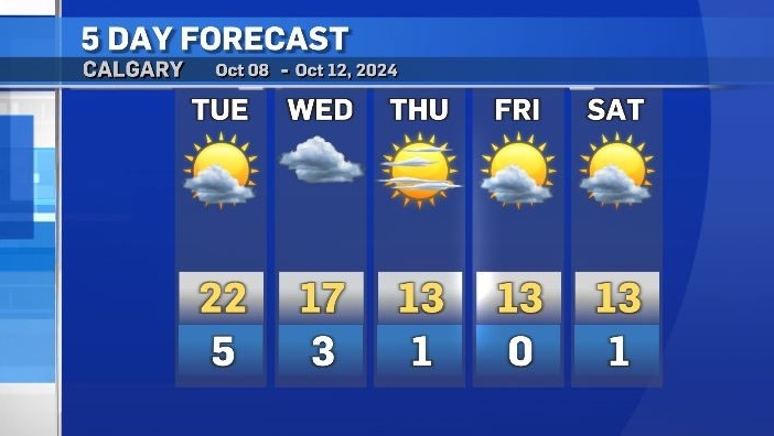
Warm Tuesday before temperatures drop nearly 10 degrees by Thursday
Tuesday will be very similar to Monday as this warm weather pattern continues for one more day.
Daytime highs will be in the low to mid 20s throughout southern Alberta with westerly winds between 20 to 40 km/h in Calgary and up to 70 km/h in the southwest corner of the province.
The main weather maker is a ridge of high pressure diverting active weather to the edges of the ridge and pulling warmer air up along the Pacific coastline.
That ridge has been held in place by low pressures system to the east and west, but this will break down late on Tuesday when that ridge to the east breaks off and travels toward the U.S. northeast.
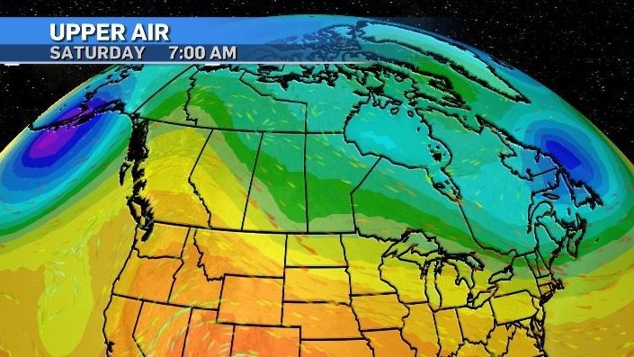
By Thursday, cooler air will sink south toward the southern borders of the Prairie provinces and a more “zonal” weather pattern will emerge – one with a more straightforward west to east flow across the region.
Daytime highs will hold steady around 13 C from Thursday through Sunday before a quick boost in temperatures starting Sunday.
Shopping Trends
The Shopping Trends team is independent of the journalists at CTV News. We may earn a commission when you use our links to shop. Read about us.


CTVNews.ca Top Stories

Jewish pro-Palestinian protesters occupy Ottawa parliament building
A group of Jewish-Canadian activists protesting Israel's ongoing armed offensive in Gaza have occupied a parliamentary building in Ottawa on Tuesday morning.
Toronto library apologizes after staff at east-end branch refuse to help lost girl
The Toronto Public Library is apologizing after staff at a branch in the city’s east end refused to provide a lost child with access to a telephone.
Canada Post removes deadline for Santa letter program amid strike
Canada Post says it has removed the deadline for its Santa Claus letter program amid an ongoing national workers' strike that has halted mail delivery leading up to the holiday season.
Canadian among three climbers missing on New Zealand's highest peak
A Canadian is among three climbers missing after they'd planned to climb New Zealand's highest peak.
2 Ontario men charged after police seize US$40M in suspected cocaine from tractor-trailer in Illinois
Two Ontario men are facing charges after police in the U.S. say they seized 540 kilograms of cocaine from a tractor-trailer along Interstate 80 in Illinois.
Quebec prisons on lockdown after correctional officer severely beaten
Quebec prisons were in lockdown on Tuesday after a correction officer at the Sorel-Tracy detention centre was attacked this week.
This salad brand is being recalled again. Here's why
A Taylor Farms salad kit is being recalled over concerns of a salmonella contamination, according to the Canadian Food Inspection Agency.
After meeting with Trump, Trudeau to brief opposition leaders
Prime Minister Justin Trudeau will meet with all opposition leaders today before question period to brief them about his meeting with U.S. president-elect Donald Trump.
Young Manitoba woman dies after medical emergency during dental appointment
The Manitoba Dental Association (MDA) said it is investigating a critical incident where a young woman from the Morden-Winkler area died following a dental appointment.
Edmonton
-

Residents of Alta. town vote in favour of bylaw banning rainbow flags, crosswalks
Residents of a northern Alberta town have voted in favour of a bylaw banning Pride flags and rainbow crosswalks from municipal property.
-
Alberta RCMP officer charged with 2 counts of sexual assault
Const. Bridget Morla, a Leduc RCMP officer, has been charged with two counts of sexual assault in connection with an incident that happened two years ago.
-
Police search for man wanted in Edmonton arson, extortion cases
Edmonton police are looking for a man who they say is connected to three southside arsons this fall.
Lethbridge
-

Hurricanes add Yager, Unger in blockbuster deal with Warriors
The Lethbridge Hurricanes received forward Brayden Yager and goalie Jackson Unger from the Moose Jaw Warriors in an 11-asset blockbuster trade on Monday.
-
Raiders hand Hurricanes sixth loss in a row, winning 3-2 in Prince Albert
The Hurricanes ended November with a loss, dropping a 3-2 decision to the Raiders Saturday night in Prince Albert.
-
University of Lethbridge launches geospatial insitute
Geomatics research is about to take a step forward at the University of Lethbridge.
Vancouver
-

B.C. nurse suspended 8 months for sharing patient records
A British Columbia nurse has been suspended for eight months after inappropriately accessing and sharing private patient health information, according to the professional regulator.
-
Collision closes Highway 99 exit, expect delays
Commuters are advised to expect delays on the Steveston Highway following a collision Tuesday morning in Richmond, B.C.
-
Alpine Canada eyes Panorama or Whistler, B.C., for future men's World Cup downhills
Whistler and Panorama, B.C., are candidates to host men's World Cup downhill ski races in the future.
Vancouver Island
-
B.C. nurse suspended 8 months for sharing patient records
A British Columbia nurse has been suspended for eight months after inappropriately accessing and sharing private patient health information, according to the professional regulator.
-
'A piece of our hearts missing:' B.C. family announces tragic end to search for missing man with dementia
A 64-year-old man who went missing from his Saanich long-term care home last month has been found deceased on the Westshore – with his wallet and Cleveland Browns trading cards, according to family.
-
Alpine Canada eyes Panorama or Whistler, B.C., for future men's World Cup downhills
Whistler and Panorama, B.C., are candidates to host men's World Cup downhill ski races in the future.
Saskatoon
-

Meth, guns seized during drug trafficking bust in North Battleford, 3 charged: RCMP
Saskatchewan RCMP have charged three people and seized multiple guns following a drug trafficking investigation in the Battlefords area.
-
Saskatchewan auditor to release report on foreign-owned farmland, procuring hotels
Saskatchewan's provincial auditor is to release a report today outlining government programs and services that need improvement.
-
Man fined more than $10K after 35 walleye found in Sask. home, elephant ivory rosaries and rings seized
Environment and Climate Change Canada (ECCC) says a man is facing a fine of $10,550 after 35 walleye fish were found in his Saskatchewan home and four rosaries and three rings made of elephant ivory were seized after an initial search of luggage at Toronto Pearson International Airport.
Regina
-

Woman taken to hospital with life-threatening injuries after early morning shooting: Regina police
Regina police say a woman was taken to hospital early Tuesday morning with what were believed to be life-threatening injuries following a possible shooting.
-
Saskatchewan auditor to release report on foreign-owned farmland, procuring hotels
Saskatchewan's provincial auditor is to release a report today outlining government programs and services that need improvement.
-
Man fined more than $10K after 35 walleye found in Sask. home, elephant ivory rosaries and rings seized
Environment and Climate Change Canada (ECCC) says a man is facing a fine of $10,550 after 35 walleye fish were found in his Saskatchewan home and four rosaries and three rings made of elephant ivory were seized after an initial search of luggage at Toronto Pearson International Airport.
Toronto
-
 BREAKING
BREAKING Process around Ontario Place redevelopment was 'unfair' and didn't follow rules: AG
Ontario's auditor general is slamming the Ford government for failing to follow proper process around the redevelopment of Ontario Place, including a revelation that senior staff communicated directly with Therme Canada and other applicants while proposals were still being accepted.
-
Toronto may impose cap on number of Uber, Lyft drivers in the city
Toronto could soon introduce a cap on the number of licences issued to drivers who work for ride-hailing services, including Uber and Lyft.
-
First snowfall expected for Toronto this week
Toronto is expecting it's first snowfall of the season this week.
Montreal
-

Quebec prisons on lockdown after correctional officer severely beaten
Quebec prisons were in lockdown on Tuesday after a correction officer at the Sorel-Tracy detention centre was attacked this week.
-
Winter tires now mandatory in Quebec, Montreal police checking
Montreal police (SPVM) officers were out on Tuesday stopping drivers and checking their tires to be sure they were ready for winter.
-
Quebec to investigate 2 CEGEPs in connection with student safety
Two English-language CEGEPs in Montreal are expected to be investigated by the Quebec Ministry of Higher Education following student complaints about a tense climate due to the war in the Middle East.
Atlantic
-

Canada-wide warrant issued for N.B. man convicted of armed robbery, assault
Police in Saint John, N.B., are asking for the public’s help in finding a 26-year-old man wanted on a Canada-wide warrant.
-
Northern New Brunswick could see 'significant' snowfall this week
Environment Canada has issued a special weather statement in northern New Brunswick, warning the region could see 'significant' snowfall later this week.
-
This salad brand is being recalled again. Here's why
A Taylor Farms salad kit is being recalled over concerns of a salmonella contamination, according to the Canadian Food Inspection Agency.
Winnipeg
-

Young Manitoba woman dies after medical emergency during dental appointment
The Manitoba Dental Association (MDA) said it is investigating a critical incident where a young woman from the Morden-Winkler area died following a dental appointment.
-
Winnipeg man arrested in 1997 New Jersey murder
A Winnipeg man has been arrested in connection with a cold case investigation of a 1997 murder in New Jersey.
-
'It's a little scary': Manitoba colleges and universities beefing up security measures
As of Monday, students and staff at Red River College are being greeted by security officers at the entrances, letting them know they will require ID as of Jan. 1.
Ottawa
-
Jewish pro-Palestinian protesters occupy Ottawa parliament building
A group of Jewish-Canadian activists protesting Israel's ongoing armed offensive in Gaza have occupied a parliamentary building in Ottawa on Tuesday morning.
-
Ottawa to receive 5 cm of snow Wednesday, flurries Tuesday
Ottawa residents might soon have to start plowing their driveways with the city's first dump of snow expected this week.
-
Kingston, Ont. doctor in 'disbelief' after being ordered to repay $600K for pandemic vaccination payments
An Ontario health tribunal has ordered a Kingston, Ont. doctor to repay over $600,000 to the Ontario government for improperly billing thousands of COVID-19 vaccinations at the height of the pandemic.
Northern Ontario
-

Insults on social media lead to real-life assault in northern Ont.
A Mississauga First Nation woman has been charged with assault after she took offence to comments about her on social media.
-
Five years after toddler's brutal death, Northern Ont. family struggles to find peace, justice
A North Bay family is struggling to find peace and justice as the five-year anniversary of the brutal death of toddler Oliver McCarthy approaches.
-
Suspect charged with murder in death of North Bay man
A 32-year-old has been charged with first-degree murder in connection with a death in Magnetawan on Nov. 21.
Barrie
-

Man accused of indecent act in Georgina arrested and charged
A man accused of an indecent act in the Town of Georgina has been arrested and charged.
-
Weapons and drug charges withdrawn against disbarred lawyer arrested in Wasaga Beach
The Crown has withdrawn charges due to a lack of evidence against a disbarred lawyer facing drug trafficking and weapons offences following a traffic stop in Wasaga Beach last summer.
-
'We will get through this situation,' Gravenhurst battles storm damage
In its third State of Emergency update since the area was hit with over a metre of snow, Gravenhurst staff are asking people from outside the area to stay home and not check on how their cottages fared during the storm.
Kitchener
-

Nearly $300,000 worth of drugs seized in Oxford County, Kitchener
OPP and Woodstock police began 'Project NAPOLI' because of drug trafficking activity in Oxford, Brant, Elgin, Norfolk, Woodstock, London and Waterloo.
-
Wanted man known to visit Kitchener, Hamilton, Toronto, Halton Region and Peel Region
Police are looking for a wanted man who has breached his statutory release.
-
Waterloo water main break causes traffic slowdowns
Traffic on Weber Street North has been reduced to one lane in each direction after a water main break near Lincoln Road.
London
-

Charges laid after 'shelter in place' in Tillsonburg
Police in Tillsonburg have seized a firearm and illegal drugs after an investigation last week.
-
Nearly $300,000 worth of drugs seized in Oxford County, Kitchener
OPP and Woodstock police began 'Project NAPOLI' because of drug trafficking activity in Oxford, Brant, Elgin, Norfolk, Woodstock, London and Waterloo.
-
School closures and bus cancellations, more squalls expected Tuesday morning
It remains a winter wonderland across the London region, with snow blanketing midwestern Ontario.
Windsor
-

Average home price increases to $584,452 in Windsor-Essex
There was an increase in the average sales price of homes and market activity in the region, according to the Windsor-Essex County Association of Realtors.
-
Highway 401 driver charged after Good Samaritan calls police
A 42-year-old driver on Highway 401 is facing impaired charges after a Good Samaritan called police.
-
Driver attempts to avoid police and ends up in ditch: CKPS
Chatham-Kent police have arrested a 29-year-old man who allegedly tried to evade police and ended up in a ditch.


