Warm weather comes to an abrupt end Monday night
A mild Sunday night leads into a warm start to the work week, but don’t let that deceive you. Winter storm conditions expected for much of the province, starting in northern regions Monday morning.
That snow moves into central Alberta by the afternoon, coupled with a cold front swinging through the province, bringing gusty winds and plummeting temperatures.
Wind gusts across central and southern regions could reach 70-90 km/h by Monday evening, causing blowing snow, poor visibility, and road conditions.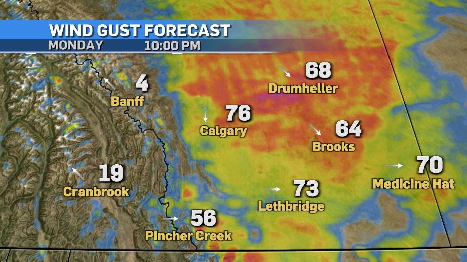
Snow tapers off through Tuesday morning as wind speeds diminish. Generally, 5-10 cm is expected across central and southern Alberta, but the foothills may see greater totals.
The cold settles in Tuesday, with temperatures slightly moderating mid-week before warm weather returns in the second half of the week.
Here’s the five day:
Monday:
- Sunny in the morning, increasing cloudiness late afternoon
- Daytime high: 9 C
- Overnight: Temperatures plummet, winds gust to 70 km/h, blowing snow, low -16 C, wind chill -25
Tuesday:
- Chance of early morning flurries, partly cloudy after that
- Daytime high: -13 C
- Overnight: Clearing, -22 C
Wednesday:
- Mostly sunny
- Daytime high: -9 C
- Overnight: Becoming mostly cloudy, -12 C
Thursday:
- Becoming mostly cloudy
- Daytime high: 4 C
- Overnight: Partly cloudy, -2 C
Friday:
- Clearing
- Daytime high: 2 C
- Overnight: Clearing, -1 C


CTVNews.ca Top Stories

LIVE
LIVE B.C. seeks ban on using drugs in 'all public spaces,' shifting approach to decriminalization
The B.C. government is moving to have drug use banned in 'all public spaces,' marking a major shift in the province's approach to decriminalization.
Air traveller complaints to Canadian Transportation Agency hit new high
The Canadian Transportation Agency has hit a record high of more than 71,000 complaints in a backlog. The quasi-judicial regulator and tribunal tasked with settling disputes between customers and the airlines says the backlog is growing because the number of incoming complaints keeps increasing.
Orca calf that was trapped in B.C. lagoon for weeks swims free
An orca whale calf that has been stranded in a B.C. lagoon for weeks after her pregnant mother died swam out on her own early Friday morning.
AFN chief says Air Canada offered a 15% discount after her headdress was mishandled
After the Assembly of First Nations' national chief complained to Air Canada about how staffers treated her and her ceremonial headdress on a flight this week, she says the airline responded by offering a 15 per cent discount on her next flight.
Sophie Gregoire Trudeau on navigating post-political life, co-parenting and freedom
Sophie Gregoire Trudeau says there is 'still so much love' between her and Prime Minister Justin Trudeau, as they navigate their post-separation relationship co-parenting their three children.
U.S. flight attendant indicted in attempt to record teen girl in airplane bathroom
An American Airlines flight attendant was indicted Thursday after authorities said he tried to secretly record video of a 14-year-old girl using an airplane bathroom last September.
76ers All-Star centre Joel Embiid says he has Bell's palsy
Philadelphia 76ers All-Star centre Joel Embiid has been diagnosed with Bell’s palsy, a form of facial paralysis he says has affected him since before the play-in tournament.
More than 115 cases of eye damage reported in Ontario after solar eclipse
More than 115 people who viewed the solar eclipse in Ontario earlier this month experienced eye damage after the event, according to eye doctors in the province.
DEVELOPING
DEVELOPING Bird flu outbreaks: WHO weighs in on public health risk
The current overall public health risk posed by the H5N1 bird flu virus is low, the World Health Organization said on Friday, but urged countries to stay alert for cases of animal-to-human transmission.
Shopping Trends
The Shopping Trends team is independent of the journalists at CTV News. We may earn a commission when you use our links to shop. Read about us.


Edmonton
-

Brett Kissel curse? Radio host starts petition to stop singer from performing anthem at Oilers playoff games
An Edmonton radio host created a petition to stop country music singer Brett Kissel from performing the anthem at Oilers playoff games – and Kissel signed it.
-
Toxic testing standoff: Family leaves house over air quality
A Sherwood Park family says their new house is uninhabitable. The McNaughton's say they were forced to leave the house after living there for only a week because contaminants inside made it difficult to breathe.
-
Child sexual exploitation charges laid against Alberta RCMP officer
An Alberta RCMP officer has been charged with child sexual exploitation offences.
Lethbridge
-

Multiple grass fires sparked near Kipp rail yard
It was a busy Wednesday evening for fire crews in Lethbridge County after multiple grass fires were sparked near the Kipp rail yard.
-
Former U of L student awarded diversity, equity and inclusion medal by NASA
A former University of Lethbridge student has been awarded the Medal for Diversity, Equity, Inclusion and Equity by NASA.
-
Oilers get hat trick from MacNeil en route to 4-1 win over Bandits
The Okotoks Oilers bounced back against the Bandits Wednesday night, defeating Brooks 4-1.
Vancouver
-
LIVE
LIVE B.C. seeks ban on using drugs in 'all public spaces,' shifting approach to decriminalization
The B.C. government is moving to have drug use banned in 'all public spaces,' marking a major shift in the province's approach to decriminalization.
-
'Many witnesses' in area during deadly stabbing in White Rock, B.C., investigators say
Homicide detectives investigating a fatal stabbing in White Rock, B.C., say there were several witnesses in the area during the altercation between the 26-year-old victim and the perpetrator who remains at large.
-
Orca calf that was trapped in B.C. lagoon for weeks swims free
An orca whale calf that has been stranded in a B.C. lagoon for weeks after her pregnant mother died swam out on her own early Friday morning.
Vancouver Island
-
LIVE
LIVE B.C. seeks ban on using drugs in 'all public spaces,' shifting approach to decriminalization
The B.C. government is moving to have drug use banned in 'all public spaces,' marking a major shift in the province's approach to decriminalization.
-
Orca calf that was trapped in B.C. lagoon for weeks swims free
An orca whale calf that has been stranded in a B.C. lagoon for weeks after her pregnant mother died swam out on her own early Friday morning.
-
Vehicle involved in fatal B.C. hit-and-run crash located, police say
Mounties have found a vehicle believed to have struck and killed a young woman on Vancouver Island in a hit-and-run crash last week.
Saskatoon
-

Four people arrested after attempted armed robbery in Saskatoon
Four people, including two teen girls, were arrested and charged after an attempted armed robbery on Thursday evening.
-
Blades, Warriors prepare for first all Sask. conference final in 31 years
For the first time since 1993 two Saskatchewan teams will face each other in the Western Hockey League’s (WHL) Eastern Conference Final as the Moose Jaw Warriors and Saskatoon Blades get their third round series underway Friday night
-
Here's where fire bans and restrictions are in effect in Sask.
Fire restrictions are currently in effect for three Saskatchewan provincial parks and multiple rural and urban municipalities (RM) and individual communities around the province.
Regina
-

RCMP identify victim, charge man with murder in connection to southeast Sask. homicide investigation
RCMP have identified 28-year-old Brianna Hayes from Oxbow, Sask. as the victim in an ongoing homicide investigation in the province’s southeast. As a result, police have charged 24-year-old Taylor Japp, also from Oxbow with second degree murder, an RCMP news release said.
-
Regina police officer injured after being accidentally shot by fellow officer's gun
An investigation is underway after a Regina police officer was accidentally shot by a fellow officer’s gun during the search of a house early Friday morning.
-
Here's where fire bans and restrictions are in effect in Sask.
Fire restrictions are currently in effect for three Saskatchewan provincial parks and multiple rural and urban municipalities (RM) and individual communities around the province.
Toronto
-

More than 115 cases of eye damage reported in Ontario after solar eclipse
More than 115 people who viewed the solar eclipse in Ontario earlier this month experienced eye damage after the event, according to eye doctors in the province.
-
'Extremely traumatizing:' Boy, 11, struck by transport truck in Etobicoke
An 11-year-old boy struck by a transport truck in Etobicoke on Friday morning suffered critical injuries and is receiving treatment at a Toronto trauma centre, police say.
-
'I was scared': Ontario man's car repossessed after missing two repair loan payments
An Ontario man who took out a loan to pay for auto repairs said his car was repossessed after he missed two payments.
Montreal
-

Investigation underway after worker dies at Port of Montreal
Officials with Quebec's workplace safety board are being sent to the Port of Montreal on Friday after a worker was killed on the job.
-
Bomb squad called in after dynamite sticks found in Montreal
Montreal police are sending a bomb squad to an east-end neighbourhood Friday afternoon after sticks of dynamite were found on a sidewalk outside a residential building.
-
Taylor Swift dons Montreal designer's dress in 'Fortnight' video
A pair of Montreal designers' work has now been viewed over 41 million times. Taylor Swift dons a Victorian throwback black gown in her latest music video, 'Fortnight', designed by UNTTLD due Simon Belanger and Jose Manuel Saint-Jacques.
Atlantic
-

First court appearance for boy and girl charged in death of Halifax 16-year-old
A girl and a boy, both 14 years old, made their first appearance today in a Halifax courtroom, where they each face a second-degree murder charge in the stabbing death of a 16-year-old high school student.
-
Historic church in Bridgetown, N.S., destroyed by fire
A church in Bridgetown, N.S., has been destroyed by a Friday morning fire.
-
P.E.I. Cyberbullying Awareness Day just the beginning for father of teen
The first-ever Cyberbullying Awareness Day on Prince Edward Island may have passed but for the father of the boy the day was created to remember, the job isn’t close to done.
Winnipeg
-

Serving up memories: Closed Winnipeg restaurants dish out history
Take an illustrated look back at the culinary history of Winnipeg.
-
AFN chief says Air Canada offered a 15% discount after her headdress was mishandled
After the Assembly of First Nations' national chief complained to Air Canada about how staffers treated her and her ceremonial headdress on a flight this week, she says the airline responded by offering a 15 per cent discount on her next flight.
-
Missing blind pug reunited with Manitoba family after 16 days
A blind pug has been safely returned to its home in Manitoba after going missing for 16 days.
Ottawa
-

'Too young to have breast cancer': Rates among young Canadian women rising
Breast cancer rates are rising in Canada among women in their 20s, 30s and 40s, according to research by the University of Ottawa (uOttawa).
-
Trucker from Newfoundland missing in eastern Ontario
Ontario Provincial Police are asking for the public's help in locating a missing man from Newfoundland who disappeared in eastern Ontario.
-
Queen’s University names award-winning journalist Shelagh Rogers as next chancellor
Queen’s University says renowned Canadian broadcaster and alumna, Shelagh Rogers will serve as its 16th chancellor starting July 1.
Northern Ontario
-

Northern Ont. hunters fined $8,500 for illegal moose hunt
Two hunters from North Bay, Ont., and a third from Temagami pled guilty recently to offences they committed during a 2022 moose hunt.
-
Sophie Gregoire Trudeau on navigating post-political life, co-parenting and freedom
Sophie Gregoire Trudeau says there is 'still so much love' between her and Prime Minister Justin Trudeau, as they navigate their post-separation relationship co-parenting their three children.
-
Police in northern Ont. attacked by person they found lying in the street
Ontario Provincial Police responding to a disturbance in West Nipissing this week discovered a conscious person lying in the street.
Barrie
-

Pedestrian struck by CP train in Alliston
A man is in serious condition after being struck by a train near Alliston.
-
Police warn of caller ID phone scams
Faking a caller identity has never been so easy.
-
Garage fire sends resident to hospital
A small garage fire sent a resident to the hospital in Huntsville.
Kitchener
-

About 10 companies interested in Wilmot land, says Minister of Economic Investment
Ontario’s Minister of Economic Investment, Job Creation and Trade says a number of companies have shown interest in a tract of land the Region of Waterloo is trying to assemble in Wilmot Township.
-
Construction worker in hospital after hit-and-run crash in Cambridge: WRPS
A 57-year-old male construction worker was transported to an out-of-region hospital with serious injuries after police say he was hit by a driver who did not remain at the scene.
-
Driver hits woman pushing 3-month-old baby in stroller
An elderly Guelph driver has been charged after hitting a woman pushing a stroller.
London
-

Portion of Highway 401 reopens following fatal crash
A fatal crash in Thames Centre closed down a portion of Highway 401 westbound. Around 2:15 a.m., first responders were called to westbound lanes of the highway between Culloden and Putnam Roads for a two-vehicle crash.
-
'It’s more than rock stars': New private jet facility a boost for London
A new private aviation centre at the London International Airport is expected to raise the city’s profile.
-
Two people taken to hospital after Oxford County crash
An unknown number of people have been taken to hospital following a crash in Oxford County. OPP are on scene of the two-vehicle crash at 37th Line and Road 74 in Zorra.
Windsor
-

Windsor police seize $120,000 in drugs
Windsor police have arrested two people after seizing $120,000 in illegal drugs.
-
Former high school teacher facing another trial
A former high school teacher who just finished one trial is now facing another.
-
Windsor resident wins $100,000 with Encore
A Windsor man is celebrating winning $100,000.


